This article is written like a travel guide. (January 2015) |
Nakhon Ratchasima
นครราชสีมา | |
|---|---|
| Nakhon Ratchasima province | |
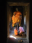
(clockwise from upper-left): Phimai Castle, Thao Suranaree Monument, Thai house at Jim Thompson Farm, Chum Phon Gate, Buddha statue at Phanom Wan Castle | |
| Nickname: Korat (Thai: โคราช) | |
| Motto(s): เมืองหญิงกล้า ผ้าไหมดี หมี่โคราช ปราสาทหิน ดินด่านเกวียน ("City of brave women. Excellent silk. Mee Korat. Stone castles. Dan Kwian clay.") | |
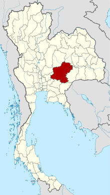
 Map of Thailand highlighting Nakhon Ratchasima province | |
| Country | Thailand |
| Capital | Nakhon Ratchasima City |
| Government | |
| • Governor | Siam Sirimongkol (since October 2022)[1] |
| Area | |
| • Total | 20,736 km2 (8,006 sq mi) |
| • Rank | Ranked 1st |
| Population (2022)[3] | |
| • Total | 2,630,058 |
| • Rank | Ranked 2nd |
| • Density | 127/km2 (330/sq mi) |
| • Rank | Ranked 35th |
| Human Achievement Index | |
| • HAI (2022) | 0.6471 "average" Ranked 30th |
| GDP | |
| • Total | baht 275 billion (US$9.5 billion) (2019) |
| Time zone | UTC+7 (ICT) |
| Postal code | 30xxx |
| Calling code | 044 |
| ISO 3166 code | TH-30 |
| Website | www |
Nakhon Ratchasima (Thai: นครราชสีมา, pronounced [ná(ʔ).kʰɔ̄ːn râːt.tɕʰā.sǐː.māː]; Northeastern Thai: นครราชสีมา, pronounced [nà(ʔ).kʰɔ᷇ːn lâːt.sā.sǐː.ma᷇ː], often called Khorat (Thai: โคราช, pronounced [kʰōː.râːt]; Northeastern Thai: โคราช, pronounced [kʰo᷇ː.lâːt])) (alternate spelling Korat) is one of Thailand's seventy-six provinces (changwat) lies in lower northeastern Thailand also called Isan. It is the country's largest province by area, has a population of approximately 2.7 million, and generates about 250 billion baht in GDP, the highest in Isan.[6] Neighbouring provinces are (clockwise, from north) Chaiyaphum, Khon Kaen, Buriram, Sa Kaeo, Prachinburi, Nakhon Nayok, Saraburi, and Lopburi.
The capital of the province is the city of Nakhon Ratchasima in Mueang Nakhon Ratchasima district, also called Khorat.
- ^ "รายนามผู้ว่าราชการจังหวัด" [List of Governors of Provinces of Thailand] (PDF). Ministry of Interior (Thailand). 2 December 2022. Retrieved 8 January 2023.
- ^ "ตารางที่ 2 พี้นที่ป่าไม้ แยกรายจังหวัด พ.ศ.2562" [Table 2 Forest area Separate province year 2019]. Royal Forest Department (in Thai). 2019. Retrieved 6 April 2021, information, Forest statistics Year 2019, Thailand boundary from Department of Provincial Administration in 2013.
- ^ รายงานสถิติจำนวนประชากรและบ้านประจำปี พ.ส.2562 [Statistics, population and house statistics for the year 2019]. Registration Office Department of the Interior, Ministry of the Interior. stat.bora.dopa.go.th (in Thai). 31 December 2019. Retrieved 26 February 2020.
- ^ "ข้อมูลสถิติดัชนีความก้าวหน้าของคน ปี 2565 (PDF)" [Human Achievement Index Databook year 2022 (PDF)]. Office of the National Economic and Social Development Council (NESDC) (in Thai). Retrieved 12 March 2024, page 34
{{cite web}}: CS1 maint: postscript (link) - ^ "Gross Regional and Provincial Product, 2019 Edition". <>. Office of the National Economic and Social Development Council (NESDC). July 2019. ISSN 1686-0799. Retrieved 22 January 2020.
- ^ Janssen, Peter (2 November 2016). "Thailand takes a long-term gamble on Isaan region". Nikkei Asian Review. Retrieved 3 November 2016.


