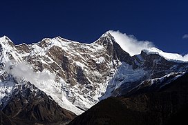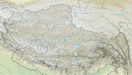
Namcha Barwa or Namchabarwa (Tibetan: གནམས་ལྕགས་འབར་བ།, Wylie: Gnams lcags 'bar ba, ZYPY: Namjagbarwa; Chinese: 南迦巴瓦峰, Pinyin: Nánjiābāwǎ Fēng) is a mountain peak lying in Tibet in the region of Pemako. The traditional definition of the Himalaya extending from the Indus River to the Brahmaputra would make it the eastern anchor of the entire mountain chain, and it is the highest peak of its own section as well as Earth's easternmost peak over 7,600 metres (24,900 ft).[3] It lies in the Nyingchi Prefecture of Tibet. It is the highest peak in the 180 km long Namcha Barwa Himal range (also called the Namjagbarwa syntaxis or Namjagbarwa Group Complex), which is considered the easternmost syntaxis/section of the Himalaya in southeastern Tibet and northeastern India where the Himalaya are said to end, although high ranges (Hengduan Mountains on the China–Myanmar border) actually continue another 300 km to the east.
- ^ a b c "High Asia II: Himalaya of Nepal, Bhutan, Sikkim and adjoining region of Tibet". Peaklist.org. Retrieved 2014-06-01.
- ^ "Peak Bagger:Himalaya, Central Nepal Himalaya, Khumbu, Ghurka Himal, Annapurna Himal, Xishapangma Area, Sikkim-Eastern Nepal Himalaya, Western Nepal Himalaya, Assam Himalaya, Punjab Himalaya, Bhutan Himalaya, Garwhal Himalaya, Ganesh Himal". Retrieved 22 October 2024.
- ^ Neate, Jill (1990). High Asia: An Illustrated History of the 7,000 Metre Peaks. Seattle: Mountaineers Books. pp. 1–4, 14–15. ISBN 0-89886-238-8.


