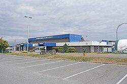
Nanaimo Airport | |||||||||||
|---|---|---|---|---|---|---|---|---|---|---|---|
 | |||||||||||
| Summary | |||||||||||
| Airport type | Public | ||||||||||
| Operator | Nanaimo Airport Commission | ||||||||||
| Location | Nanaimo | ||||||||||
| Time zone | PST (UTC−08:00) | ||||||||||
| • Summer (DST) | PDT (UTC−07:00) | ||||||||||
| Elevation AMSL | 92 ft / 28 m | ||||||||||
| Coordinates | 49°03′16″N 123°52′12″W / 49.05444°N 123.87000°W | ||||||||||
| Website | ycd | ||||||||||
| Map | |||||||||||
 | |||||||||||
| Runways | |||||||||||
| |||||||||||
| Statistics (2010) | |||||||||||
| |||||||||||
Nanaimo Airport (IATA: YCD, ICAO: CYCD) is a privately owned and operated regional airport located 7 nautical miles (13 km; 8.1 mi) south southeast of Nanaimo, British Columbia, Canada.
In 1999, the air terminal was named in honour of World War I ace Raymond Collishaw who was born in Nanaimo. The Nanaimo-Collishaw Air Terminal is the passenger terminal for the airport.
The Nanaimo Airport currently has only one available runway for instrument flight rules (IFR) conditions, runway 16. This is because the approach to the north-facing runway (runway 34) is a dogleg approach that follows the Ladysmith Harbour.
- ^ Canada Flight Supplement. Effective 0901Z 16 July 2020 to 0901Z 10 September 2020.
- ^ Synoptic/Metstat Station Information
- ^ Total aircraft movements by class of operation — NAV CANADA flight service stations

