30°50′14″N 106°06′38″E / 30.8372°N 106.1106°E
Nanchong
南充市 Nanchung | |
|---|---|
 | |
| Nickname: The fruit City | |
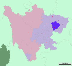
 Location of Nanchong City jurisdiction in Sichuan | |
| Coordinates (Nanchong Bureau of Civil Affairs (南充市民政局)): 30°47′29″N 106°04′31″E / 30.7913°N 106.0753°E | |
| Country | People's Republic of China |
| Province | Sichuan |
| Officiated | 1993 |
| Municipal seat | Shunqing District |
| Government | |
| • Party Secretary | Liu Hongjian |
| Area | |
| • Prefecture-level city | 12,479.96 km2 (4,818.54 sq mi) |
| • Urban | 2,527.8 km2 (976.0 sq mi) |
| • Metro | 2,527.8 km2 (976.0 sq mi) |
| Elevation | 340 m (1,120 ft) |
| Population (2020 census)[1] | |
| • Prefecture-level city | 5,607,565 |
| • Density | 450/km2 (1,200/sq mi) |
| • Urban | 1,936,534 |
| • Urban density | 770/km2 (2,000/sq mi) |
| • Metro | 1,936,534 |
| • Metro density | 770/km2 (2,000/sq mi) |
| GDP[2] | |
| • Prefecture-level city | CN¥ 151.6 billion US$ 24.3 billion |
| • Per capita | CN¥ 23,881 US$ 3,834 |
| Time zone | UTC+8 (China Standard) |
| Postal code | 637000 |
| Area code | 0817 |
| ISO 3166 code | CN-SC-13 |
| Licence plate prefixes | 川R |
| Website | nanchong |
Nanchong (Chinese: 南充; pinyin: Nánchōng; Wade–Giles: Nan-ch'ung; Sichuanese: lan2cong1) is a prefecture-level city in the northeast of Sichuan province, China, with an area of 12,479.96 km2 (4,818.54 sq mi).[3] At the 2020 census it was home to 5,607,565 people, of whom 1,936,534 lived in the built-up (or 'metro') area made of three urban districts. It is the second most populated city of Sichuan Province, after Chengdu. The administrative center is Shunqing District.[4]
- ^ "China: Sìchuān (Prefectures, Cities, Districts and Counties) - Population Statistics, Charts and Map".
- ^ 四川省统计局、国家统计局四川调查总队 (2016). 《四川统计年鉴-2016》. 中国统计出版社. ISBN 978-7-5037-7871-1.
- ^ 南充市 (in Chinese (China)). XZQH. Archived from the original on 2008-05-18. Retrieved 2008-05-17.
- ^ "南充市第七次全国人口普查公报-南充市人民政府" [Nanchong Seventh National Population Census Bulletin-Nanchong Municipal People's Government]. www.nanchong.gov.cn. Retrieved 2024-06-21.