Nanisivik | |
|---|---|
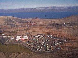
 Aerial view of Nanisivik | |
| Coordinates: 73°02′N 84°33′W / 73.033°N 84.550°W[1] | |
| Country | Canada |
| Territory | Nunavut |
| Region | Qikiqtaaluk |
| Area (2021)[2] | |
| • Land | 165.49 km2 (63.90 sq mi) |
| Highest elevation | 341 m (1,119 ft) |
| Lowest elevation | 0 m (0 ft) |
| Population (2021)[2] | |
| • Total | 0 |
| Time zone | UTC−05:00 (EST) |
| • Summer (DST) | UTC−04:00 (EDT) |
| Postal Code | X0A 0X0 |
| GNBC Code | OALHI |
| NTS Map | 048C01 |
Nanisivik (Inuktitut: ᓇᓂᓯᕕᒃ, lit. 'the place where people find things'; /nəˈniːsɪvɪk/) is a now-abandoned company town which was built in 1975 to support the lead-zinc mining and mineral processing operations for the Nanisivik Mine, in production between 1976 and 2002. The townsite is located just inland from Strathcona Sound, about 20 km (12 mi) east of the community of Arctic Bay in the Canadian territory of Nunavut.
There is a port and dock about 3.7 km (2.3 mi) north of the abandoned mine site, which was used for shipping concentrate from the site, and receiving supplies (73°04′08″N 084°32′57″W / 73.06889°N 84.54917°W). It is used by the Canadian Coast Guard for training.[3]
Nanisivik Airport, located 8 nautical miles (15 km; 9.2 mi) south,[4] was used as the main airport for Arctic Bay until 2010, when the lengthened Arctic Bay Airport took over. The airport is about 19 km (12 mi) directly southeast of Arctic Bay but the road between them is 32 km (20 mi).[5]
- ^ "Nanisivik". Geographical Names Data Base. Natural Resources Canada.
- ^ a b Cite error: The named reference
2021censuswas invoked but never defined (see the help page). - ^ "Arcticnet - Naval gazing: Looking for a High Arctic port". Archived from the original on 2007-07-15. Retrieved 2007-08-07.
- ^ Canada Flight Supplement. Effective 0901Z 16 July 2020 to 0901Z 10 September 2020.
- ^ Arctic Bay and Nanisivik Archived 2007-09-27 at the Wayback Machine

