Nanto
南砺市 | |
|---|---|
 Nanto City Hall | |
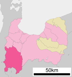
 Location of Nanto in Toyama Prefecture | |
| Coordinates: 36°35′16″N 136°55′9.8″E / 36.58778°N 136.919389°E | |
| Country | |
| Region | Chūbu (Kōshin'etsu) |
| Prefecture | |
| Government | |
| • Mayor | Mikio Tanaka |
| Area | |
| • Total | 668.64 km2 (258.16 sq mi) |
| Population (October 1, 2020) | |
| • Total | 47,976 |
| • Density | 71.76/km2 (185.9/sq mi) |
| Time zone | UTC+09:00 (JST) |
| Postal code | 939-1692 |
| Address | 1550 Araki, Nanto-shi, Toyama-ken |
| Climate | Cfa |
| Website | Official website |

Nanto (南砺市, Nanto-shi) is a city in Toyama Prefecture, Japan. It is in a mountainous area in the south-west corner of the prefecture just north of Gifu Prefecture. It is home to the Gokayama UNESCO World Heritage site. As of 28 February 2018[update], the city had an estimated population of 51,669 in 17,761 households[1] and a population density of 75.8 persons per km². Its total area is 668.64 square kilometres (258.16 sq mi).[2]
- ^ home page official statuistics(in Japanese)
- ^ Cite error: The named reference
SurveyNantowas invoked but never defined (see the help page).


