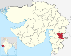
Narmada District | |
|---|---|
 Location of district in Gujarat | |
| Coordinates: 21°52′12″N 73°30′0″E / 21.87000°N 73.50000°E | |
| Country | |
| State | Gujarat |
| Headquarters | Rajpipla |
| Area | |
| • Total | 2,755 km2 (1,064 sq mi) |
| Population (2011) | |
| • Total | 590,297 |
| • Density | 210/km2 (550/sq mi) |
| Languages | |
| • Official | Gujarati |
| Time zone | UTC+5:30 (IST) |
| Vehicle registration | GJ-22 |
| Website | narmada |
Narmada district is an administrative district in the state of Gujarat in India. The district headquarters are located at Rajpipla. The district is bounded by Vadodara and Chhota Udaipur districts in the north, by Nandurbar district of Maharashtra state in the east, by Surat and Tapi districts in the south and by Bharuch district in the west. The district occupies an area of 2,755 km2 and has a population of 590,297 (as of 2011). It was 10.44% urban as of 2011.[1] As of 2011, it is the third least populous district of Gujarat (out of 33), after Dang and Porbandar.[2]
- ^ "Census GIS India". Archived from the original on 11 January 2010. Retrieved 20 November 2010.
- ^ Cite error: The named reference
districtcensuswas invoked but never defined (see the help page).


