Nemali | |
|---|---|
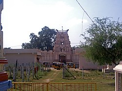
 Sri Venugopala Swamy Temple | |
 | |
| Coordinates: 17°04′04″N 80°23′48″E / 17.0678°N 80.3966°E | |
| Country | India |
| State | Andhra Pradesh |
| District | NTR |
| Mandal | Gampalagudem |
| Government | |
| • Type | Gram panchayat |
| • Sarpanch | Dubbakula Rama Krishna[1] |
| Area | |
| • Total | 8.51 km2 (3.29 sq mi) |
| Population (2011)[3] | |
| • Total | 2,867 |
| • Density | 340/km2 (870/sq mi) |
| Languages | |
| • Official | Telugu |
| Time zone | UTC+5:30 (IST) |
| PIN | 521401 |
| Lok Sabha constituency | Vijayawada |
| Vidhan Sabha constituency | Tiruvuru |
Nemali is a village located in the Gampalagudem mandal, NTR district of the Indian state of Andhra Pradesh.[4] It is under the administration of Tiruvuru revenue division..[5][6] The word Nemali means "peacock" in Telugu.
- ^ "Panchayat Development Plan Campaign". gpdp.nic.in. Retrieved 17 December 2023.
- ^ "District Census Handbook - Krishna" (PDF). Census of India. p. 16,232. Retrieved 22 February 2016.
- ^ "Census 2011". The Registrar General & Census Commissioner, India. Retrieved 14 July 2015.
- ^ "Mandal wise Villages | NTR District | India". Retrieved 20 December 2023.
- ^ "Krishna District Mandals" (PDF). Census of India. p. 524. Retrieved 16 July 2015.
- ^ "Administrative Setup". Krishna District Official Website. National Informatics Centre. Archived from the original on 20 October 2014. Retrieved 16 July 2015.

