Neuenstadt am Kocher | |
|---|---|
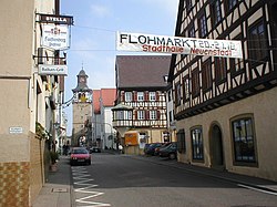
 Main street | |
Location of Neuenstadt am Kocher within Heilbronn district  | |
| Coordinates: 49°14′N 9°20′E / 49.233°N 9.333°E | |
| Country | Germany |
| State | Baden-Württemberg |
| Admin. region | Stuttgart |
| District | Heilbronn |
| Government | |
| • Mayor (2021–29) | Andreas Konrad[1] |
| Area | |
| • Total | 41.18 km2 (15.90 sq mi) |
| Elevation | 182 m (597 ft) |
| Population (2022-12-31)[2] | |
| • Total | 10,372 |
| • Density | 250/km2 (650/sq mi) |
| Time zone | UTC+01:00 (CET) |
| • Summer (DST) | UTC+02:00 (CEST) |
| Postal codes | 74196 |
| Dialling codes | 07139 |
| Vehicle registration | HN |
| Website | www.neuenstadt.de |

Neuenstadt, usually known as Neuenstadt am Kocher (German: [ˈnɔʏənʃtat ʔam ˈkɔxɐ] ; and until as late as 1800 also known as Neuenstadt an der großen Linde) is a town in Baden-Württemberg in south-western Germany with 9,600 inhabitants. It consists of Neuenstadt, the villages of Stein am Kocher, Kochertürn, Cleversulzbach and Bürg and the hamlets Brambacher Hof (part of Kochertürn), Buchhof and Lobenbacher Hof (part of Stein). The name Neuenstadt is derived from the “der neuen Stadt” or “New Town” in English.
- ^ Bürgermeisterwahl 2021, Staatsanzeiger, accessed 3 February 2022.
- ^ "Bevölkerung nach Nationalität und Geschlecht am 31. Dezember 2022" [Population by nationality and sex as of December 31, 2022] (CSV) (in German). Statistisches Landesamt Baden-Württemberg. June 2023.


