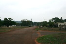
| New Mapoon Queensland | |||||||||||||||
|---|---|---|---|---|---|---|---|---|---|---|---|---|---|---|---|
 | |||||||||||||||
| Coordinates | 10°51′58″S 142°23′11″E / 10.8662°S 142.3863°E | ||||||||||||||
| Population | 412 (2021 census)[1] | ||||||||||||||
| • Density | 2.990/km2 (7.744/sq mi) | ||||||||||||||
| Area | 137.8 km2 (53.2 sq mi) | ||||||||||||||
| Time zone | AEST (UTC+10:00) | ||||||||||||||
| Location | |||||||||||||||
| LGA(s) | |||||||||||||||
| State electorate(s) | Cook | ||||||||||||||
| Federal division(s) | Leichhardt | ||||||||||||||
| |||||||||||||||
New Mapoon is a town in the Northern Peninsula Area Region and coastal locality split between the Northern Peninsula Region and Shire of Torres, Queensland, Australia.[2][3][4] In the 2021 census, the locality of New Mapoon had a population of 412 people.[1]
The people who live at New Mapoon were forcibly moved from Marpuna in the early 1960s to accommodate mining expansion on their traditional country. They now have historical association and administrative responsibility for a DOGIT area on the traditional country of the Gudang people. The residents of New Mapoon have a ranger service, which works closely with the Injinoo and other Northern Peninsula Area (NPA) community rangers to undertake land management practices in the NPA.
- ^ a b Cite error: The named reference
Census2021was invoked but never defined (see the help page). - ^ "New Mapoon – town in Northern Peninsula Area Region (entry 24128)". Queensland Place Names. Queensland Government. Retrieved 29 December 2017.
- ^ "New Mapoon – locality in Northern Peninsula Area Region (entry 46105)". Queensland Place Names. Queensland Government. Retrieved 29 December 2017.
- ^ "New Mapoon – locality in Shire of Torres (entry 48329)". Queensland Place Names. Queensland Government. Retrieved 29 December 2017.
