This article needs additional citations for verification. (January 2014) |
New Paltz, New York | |
|---|---|
| Village of New Paltz | |
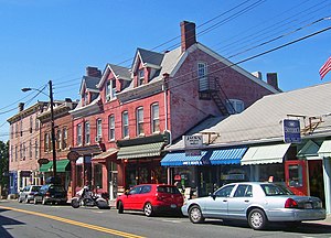
 Buildings on downtown Main Street | |
| Etymology: From Palatine German pronunciation of Pfalz | |
 Location in Ulster County and the State of New York. | |
 Location of New York in the United States | |
| Coordinates: 41°45′N 74°5′W / 41.750°N 74.083°W | |
| Country | |
| State | |
| County | Ulster |
| Founded | 1887 |
| Government | |
| • Type | Village |
| • Body | Board of Trustees |
| • Mayor | Tim Rogers[1] |
| Area | |
| • Total | 1.80 sq mi (4.66 km2) |
| • Land | 1.76 sq mi (4.56 km2) |
| • Water | 0.04 sq mi (0.10 km2) |
| Highest elevation (S village line near SE corner) | 360 ft (110 m) |
| Lowest elevation (Wallkill River at E village corner) | 160 ft (50 m) |
| Population (2020) | |
| • Total | 7,324 |
| • Density | 4,156.64/sq mi (1,605.12/km2) |
| Time zone | UTC-5 (Eastern [EST]) |
| • Summer (DST) | UTC-4 (EDT) |
| ZIP Code(s) | 12561 |
| Area code | 845 |
| FIPS code | 36-50551 |
| GNIS feature ID | 0958443 |
| Wikimedia Commons | New Paltz, New York |
| Website | village of New Paltz |
New Paltz is a village in Ulster County located in the U.S. state of New York. It is approximately 80 miles (130 km) north of New York City and 70 miles (110 km) south of Albany. The population was 7,324 at the 2020 census.[3]
New Paltz is located within the town of New Paltz. It is also home to the State University of New York at New Paltz, founded in 1828. The town is served by exit 18 on the New York State Thruway (I-87), as well as state routes 299, 32, and 208, and is about 90 minutes from both New York City and Albany.
- ^ "Mayor and Board of Trustees • Village of New Paltz". Village of New Paltz. Retrieved November 21, 2015.
- ^ "ArcGIS REST Services Directory". United States Census Bureau. Retrieved September 20, 2022.
- ^ "Quickfacts - New Paltz village, New York". United States Census Bureau. Retrieved August 14, 2021.

