| Newburn | |
|---|---|
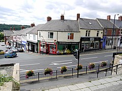
 Station Road, Newburn | |
| Population | 9,536 (2011 Ward) |
| OS grid reference | NZ1665 |
| Metropolitan borough | |
| Metropolitan county | |
| Region | |
| Country | England |
| Sovereign state | United Kingdom |
| Post town | NEWCASTLE UPON TYNE |
| Postcode district | NE15 |
| Dialling code | 0191 |
| Police | Northumbria |
| Fire | Tyne and Wear |
| Ambulance | North East |
| UK Parliament | |
Newburn is a village and district of Newcastle upon Tyne, in Tyne and Wear, England. Situated on the North bank of the River Tyne, it is built rising up the valley from the river. It is situated approximately 5 miles (8 km) from the city centre, 14 miles (23 km) east of Hexham and 13 miles (21 km) south south west of Morpeth. In the 2001 census, the population was given as 9,301,[1] increasing to 9,536 at the 2011 Census.[2] Newburn is in the Newcastle upon Tyne district of Tyne and Wear and is part of the parliamentary constituency of Newcastle upon Tyne North.
Historically, the area was larger than Newcastle upon Tyne as it was the most eastern fordable point of the River Tyne. The area has Roman remains, and a Norman church dating from 1070 AD. In 1640, the Battle of Newburn took place. The area grew with the Industrial Revolution with the discovery of coal, and in 1822 Spencer's Steelworks was opened. The village's steelworks fell into decline after the First World War, and the area is now home to a country park and various leisure facilities.
- ^ "Newburn - 2001 Census". Newcastle City Council. Retrieved 29 August 2010.
- ^ "Newcastle-upon-Tyne ward population 2011". Retrieved 5 July 2015.

