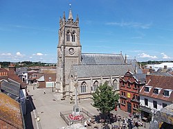
Newport and Carisbrooke | |
|---|---|
Civil parish | |
 Newport | |
| Coordinates: 50°41′43″N 1°18′21″W / 50.695207°N 1.3059568°W | |
| Country | England |
| Primary council | Isle of Wight |
| County | Isle of Wight |
| Region | South East |
| Status | Parish |
| Main settlements | Newport, Carisbrooke, Apesdown, Barton, Bowcombe, Clatterford, Cross Lane, Fairlee, Forest Side, Gunville, Hunny Hill, Pan, Parkhurst, Rowridge, Shide and Staplers |
| Area | |
| • Total | 54.44 km2 (21.02 sq mi) |
| Population (2011) | |
| • Total | 25,496 |
| • Density | 470/km2 (1,200/sq mi) |
| Website | https://www.newportwight.org.uk/ |
Newport and Carisbrooke, formerly just Newport, is a civil parish on the Isle of Wight, in the county of the Isle of Wight, England. The parish includes the settlements of Newport, Carisbrooke, Apesdown, Barton, Bowcombe, Clatterford, Cross Lane, Fairlee, Forest Side, Gunville, Hunny Hill, Pan, Parkhurst, Rowridge, Shide and Staplers. In 2011 the parish had a population of 25,496.[1] The parish touches Arreton, Brighstone, Calbourne, Newtown and Porchfield, Chillerton and Gatcombe, Havenstreet and Ashey, Northwood, Shorwell, Whippingham and Wootton Bridge.[2] There are 338 listed buildings in Newport and Carisbrooke.[3] The community council is based in The Granary in Newport.[4]
- ^ "Newport and Carisbrooke". City Population De. Retrieved 24 September 2021.
- ^ "Newport and Carisbrooke". Ordnance Survey. Retrieved 24 September 2021.
- ^ "Listed buildings in Newport, Isle of Wight". British Listed Buildings. Retrieved 24 September 2021.
- ^ "Contact us". Newport and Carisbrooke Community Council. Retrieved 24 September 2021.