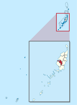
Ngatpang
Ngatpard | |
|---|---|
| Ngatpang | |
 Radio tower of Japanese army, Ngatpang State | |
 Location of Ngatpang in Palau | |
| Country | |
| 1st Constitutional Convention | January 25, 1982 |
| Capital | Ngereklmadel |
| Government | |
| • Body | Ngatpang State Legislature |
| • Governor | Jersey Iyar[1] |
| Area | |
| • Total | 47 km2 (18 sq mi) |
| Population (2020 Census) | |
| • Total | 289 |
| • Density | 6.1/km2 (16/sq mi) |
| • Official languages | Palauan English |
| • Summer (DST) | Palau Time – PWTTime Zone (Standard Time) |
| Area code | 535 |
| ISO 3166 code | PW-224 |
Ngatpang is one of Palau's sixteen states. It comprises an area of around 47 square kilometers in the west of Palau's largest island, Babeldaob, facing onto Ngeremeduu Bay. It has a population of 282, making it Palau's 9th largest state in population.
Ibobang is in Ngatpang.[2] It is a community dedicated to the practice of the Modekngei religion.
- ^ "Ngatpang Delegate Race Narrows as Governor Iyar Considers Withdrawal". Island Times. 27 August 2024.
- ^ Cook, Ben. Federated States of Micronesia and Palau. Other Places Publishing, 2010. ISBN 0982261934, 9780982261934. p. 207. " Only about 8% of Palauans practice Modekngei, most of whom reside in the same village, Ibobang. This small town of less than 100 in Ngatpang state[...]"
