Nimrod | |
|---|---|
 Entrance to Nimrod | |
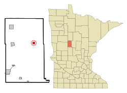
 Location of Nimrod, Minnesota | |
| Coordinates: 46°38′15″N 94°52′42″W / 46.63750°N 94.87833°W | |
| Country | United States |
| State | Minnesota |
| County | Wadena |
| Incorporated as a city | December 4, 1946[1] |
| Area | |
| • Total | 1.01 sq mi (2.61 km2) |
| • Land | 0.95 sq mi (2.47 km2) |
| • Water | 0.05 sq mi (0.14 km2) |
| Elevation | 1,322 ft (403 m) |
| Population (2020) | |
| • Total | 84 |
| • Density | 88.05/sq mi (34.01/km2) |
| Time zone | UTC-6 (Central (CST)) |
| • Summer (DST) | UTC-5 (CDT) |
| Area code | 218 |
| FIPS code | 27-46294[4] |
| GNIS feature ID | 2395236[3] |
Nimrod is a city in Wadena County, Minnesota, United States. The population was 69 at the 2010 census,[5] making it one of the smallest incorporated towns in Minnesota, though it is included on most major maps. Nimrod was incorporated as a city in 1946.[1] The town is named after the Biblical Nimrod.[1]
Minnesota State Highway 227 has its eastern terminus in Nimrod, having travelled 11 miles from Sebeka, the western terminus.
- ^ a b c "Minnesota Place Names - Township and Village Information". Archived from the original on June 15, 2011. Retrieved September 27, 2010.
- ^ "2020 U.S. Gazetteer Files". United States Census Bureau. Retrieved July 24, 2022.
- ^ a b U.S. Geological Survey Geographic Names Information System: Nimrod, Minnesota
- ^ "U.S. Census website". United States Census Bureau. Retrieved January 31, 2008.
- ^ "2010 Census Redistricting Data (Public Law 94-171) Summary File". American FactFinder. U.S. Census Bureau, 2010 Census. Retrieved April 23, 2011.[dead link]