 | |
| Location | Between Newcastleton and Hawick, Liddesdale, Roxburghshire, Scottish Borders, Scotland |
|---|---|
| Coordinates | 55°16′02.93″N 2°45′39.12″W / 55.2674806°N 2.7608667°W |
| Type | Stone circle |
| History | |
| Periods | Early Bronze Age |
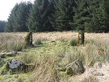
Ninestane Rig (English: Nine Stone Ridge) is a small stone circle in Scotland near the English border. Located in Roxburghshire, near to Hermitage Castle, it was probably made between 2000 BC and 1250 BC, during the Late Neolithic or early Bronze Age (Bronze Age technology reached the Borders around 1750 BC).[1] It is a scheduled monument (a nationally important archaeological site given special protections) and is part of a group with two other nearby ancient sites,[2] these being Buck Stone standing stone[3][4] and another standing stone at Greystone Hill. Settlements appear to have developed in the vicinity of these earlier ritual features in late prehistory and probably earlier.[2]
The circle (actually slightly oval in form) consists of eight stones fast in the earth (a ninth stone has fallen inwards and lies flat), but six of these are now just stumps of 2 feet (0.61 m) or less. Of the two large standing stones remaining, one is a regular monolith a little under 7 feet (2.1 m) tall and the other, a pointed stone, is a little over 4 feet (1.2 m) tall.[5][6][A] According to the Royal Commission on the Ancient and Historical Monuments of Scotland, a number of similar circles formerly existed in the immediate area; the stones have been removed, but the hollow in the center of each circle and marks in the earth showing the former positions of the stones are still visible. In the immediate area there is also a street of circular pits 8 to 10 feet (2.4 to 3.0 m) deep which may have formed the shelters of the people who set up the circles, although this is not certain.[5]
Ninestane Rig is actually the name of the low hill (943 feet (287 m) high, 4 miles (6.4 km) long and 1 mile (1.6 km) broad)[7] atop which the stone circle stands but is also usually used to designate the circle itself (which is also sometimes called Nine Stones,[2][8] not be confused with the Nine Stones circle near Winterbourne Abbas in Dorset[9] or the Nine Stones at Altarnun in Cornwall, nor Nine Stone Rig in East Lothian[10] or Nine Standards Rigg in Cumbria.)
- ^ Hall, Alan (1993). The Border Country – A Walker's Guide. Cicerone Guides. Cicerone Press. p. 16. ISBN 978-1852841164.
- ^ a b c SKM Enviros. "Chapter 9: Archaeology and Cultural Heritage" (PDF). Windy Edge Wind Farm Environmental Statement. Infinis. p. 10. Retrieved 3 April 2014.
- ^ Gary Buckham. "066 Buck Stone, Buckstone Rig, Newcastleton". Ancient Stones. Retrieved 3 April 2014.
- ^ "Hermitage, The Buck Stone". ScotlandsPlaces. Retrieved 5 April 2014.
- ^ a b Gary Buckham. "070 Stone Circle, Ninestanes Rig, Newcastleton". Ancient Stones. Retrieved 5 April 2014.
- ^ Martin McCarthy (2002). "Ninestane Rig". Ancient Scotland. Retrieved 3 April 2014.
- ^ Cite error: The named reference
eb1911was invoked but never defined (see the help page). - ^ "NY5197: Nine Stones Stone Circle". Geograph Britain and Ireland. Geograph Project Limited. Retrieved 5 April 2014.
- ^ Historic England. "The Nine Stones (453624)". Research records (formerly PastScape). Retrieved 3 April 2014.
- ^ "Nine Stone Rig - Stone Circle in Scotland in East Lothian". The Megalithic Portal. Retrieved 3 April 2014.
