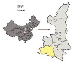
Ningqiang County
宁强县 Ningkiang | |
|---|---|
 Station along the Yangpingguan–Ankang railway | |
 Location in Hanzhong | |
 Hanzhong in Shaanxi | |
| Country | People's Republic of China |
| Province | Shaanxi |
| Prefecture-level city | Hanzhong |
| Area | |
| • Total | 3,246 km2 (1,253 sq mi) |
| Elevation | 800 m (2,600 ft) |
| Highest elevation | 2,103.7 m (6,901.9 ft) |
| Lowest elevation | 520 m (1,710 ft) |
| Population (2019) | |
| • Total | 324,318[1] |
| Time zone | UTC+8 (China standard time) |
| Postal code | 724400 |
| Licence plates | 陕F |
| Website | www |
Ningqiang County (simplified Chinese: 宁强县; traditional Chinese: 寧強縣; pinyin: Níngqiáng Xiàn) is a county and both the southwesternmost and westernmost county-level division of Shaanxi province, China, bordering both Sichuan and Gansu. It is under the administration of Hanzhong City. The source of the Han River is located in the county.[2]
Ningqiang is one of the counties with a sizable number of Qiang and Yi minorities.[3][4][5]
As a result of the 2008 Sichuan earthquake, 500 buildings in the county collapsed and seven people were killed, making it the worst hit area in Shaanxi.[6]
- ^ "China Population www.ceicdata.com". ceicdata. Retrieved 2021-01-04.
- ^ "宁强县位于陕...宁强概况 - 宁强县人民政府". www.nq.gov.cn. Retrieved 2021-02-07.
- ^ "UNESCO - Qiang New Year festival". ich.unesco.org. Retrieved 2021-02-07.
- ^ "陕西宁强县羌族文化保护传承工作有特色_文化艺术网-文化艺术报-互联网新闻信息服务许可". www.whysw.org. Retrieved 2021-02-07.
- ^ "宁强羌族后裔的文化复兴之路(组图)_中国经济网——国家经济门户". www.ce.cn. Retrieved 2021-02-07.
- ^ Wang, Wei; Fu, Wei; Wu, Jin; Ma, Xian-cang; Sun, Xue-li; Huang, Yi; Hashimoto, Kenji; Gao, Cheng-ge (2012-07-23). Yoshikawa, Takeo (ed.). "Prevalence of PTSD and Depression among Junior Middle School Students in a Rural Town Far from the Epicenter of the Wenchuan Earthquake in China". PLOS ONE. 7 (7): e41665. Bibcode:2012PLoSO...741665W. doi:10.1371/journal.pone.0041665. ISSN 1932-6203. PMC 3402444. PMID 22911838.