Nishapur County
Persian: شهرستان نیشاپور | |
|---|---|
 Mount Binalud, located within the county | |
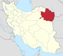
 Location of Nishapur County in Razavi Khorasan province (top left, pink) | |
 Location of Razavi Khorasan province in Iran | |
| Coordinates: 36°25′N 58°40′E / 36.417°N 58.667°E[1] | |
| Country | |
| Province | Razavi Khorasan |
| Named for | Shapur I |
| Capital | Nishapur |
| Districts | Central, Sarvelayat |
| Area | |
| • Total | 5,653 km2 (2,183 sq mi) |
| Population (2016)[2] | |
| • Total | 451,780 |
| • Density | 80/km2 (210/sq mi) |
| Demonym | Neyshaburi |
| Time zone | UTC+3:30 (IRST) |
| Nishapur County at GEOnet Names Server | |
Nishapur County (Persian: شهرستان نیشاپور)[a] is in Razavi Khorasan province, Iran. Its capital is the city of Nishapur,[3] the second largest city in the province and the third largest city in Eastern Iran.[citation needed]
- ^ OpenStreetMap contributors (3 November 2024). "Nishapur County" (Map). OpenStreetMap (in Persian). Retrieved 3 November 2024.
- ^ Cite error: The named reference
2016 Razavi Khorasan Provincewas invoked but never defined (see the help page). - ^ Habibi, Hassan (c. 2015) [Approved 21 June 1369]. Approval of the organization and chain of citizenship of the elements and units of the divisions of Khorasan province, centered in Mashhad. rc.majlis.ir (Report) (in Persian). Ministry of the Interior, Defense Political Commission of the Government Council. Proposal 3223.1.5.53; Approval Letter 3808-907; Notification 84902/T125K. Archived from the original on 17 November 2015. Retrieved 6 January 2024 – via Islamic Parliament Research Center.
Cite error: There are <ref group=lower-alpha> tags or {{efn}} templates on this page, but the references will not show without a {{reflist|group=lower-alpha}} template or {{notelist}} template (see the help page).