You can help expand this article with text translated from the corresponding articles in French and Spanish. (December 2009) Click [show] for important translation instructions.
|
 Noirmoutier Island image from satellite Spot | |
| Geography | |
|---|---|
| Location | Atlantic Ocean |
| Coordinates | 46°58′N 2°13′W / 46.967°N 2.217°W |
| Area | 49 km2 (19 sq mi) |
| Length | 19 km (11.8 mi) |
| Width | 6 km (3.7 mi) |
| Highest elevation | 20 m (70 ft) |
| Highest point | No named |
| Administration | |
France | |
| Region | Pays de la Loire |
| Department | Vendée |
| Arrondissement | Les Sables-d'Olonne |
| Demographics | |
| Population | 9,590 |
| Pop. density | 195.76/km2 (507.02/sq mi) |
| Ethnic groups | French people |
| Official name | Marais Breton, Baie de Bourgneuf, Ile de Noirmoutier et Forêt de Monts |
| Designated | 2 February 2017 |
| Reference no. | 2283[1] |

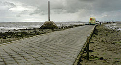
Noirmoutier (also French: Île de Noirmoutier, pronounced [nwaʁmutje]; Breton: Nervouster, Nermouster) is a tidal island off the Atlantic coast of France in the Vendée department (85).
- ^ "Marais Breton, Baie de Bourgneuf, Ile de Noirmoutier et Forêt de Monts". Ramsar Sites Information Service. Retrieved 25 April 2018.
