Noord-Beveland
North Beveland | |
|---|---|
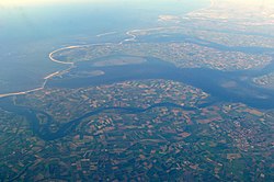
 Aerial view of Noord-Beveland | |
 Location in Zeeland | |
| Coordinates: 51°35′N 3°45′E / 51.583°N 3.750°E | |
| Country | Netherlands |
| Province | Zeeland |
| Established | 1 January 1995 |
| Government | |
| • Body | Municipal council |
| • Mayor | Marcel Delhez (VVD) |
| Area | |
• Total | 121.58 km2 (46.94 sq mi) |
| • Land | 85.96 km2 (33.19 sq mi) |
| • Water | 35.62 km2 (13.75 sq mi) |
| Elevation | 1 m (3 ft) |
| Population (January 2021)[4] | |
• Total | 7,581 |
| • Density | 88/km2 (230/sq mi) |
| Demonym | Noord-Bevelander |
| Time zone | UTC+1 (CET) |
| • Summer (DST) | UTC+2 (CEST) |
| Postcode | 4484–4499 |
| Area code | 0113 |
| Website | www |
Noord-Beveland (Dutch pronunciation: [ˈnoːrd ˌbeːvəlɑnt] ; "North Beveland") is a municipality and region in the southwestern Netherlands and a former island, now part of the Walcheren-Zuid-Beveland-Noord-Beveland peninsula. Noord-Beveland is enclosed by the Oosterschelde estuary to the north, and the former straits, now combined lake, of Veerse Meer and Zandkreek to the south. As part of the Delta Works, dams have connected Noord-Beveland to Walcheren and Zuid-Beveland.
- ^ "Collegeleden" [Members of the board] (in Dutch). Gemeente Noord-Beveland. Archived from the original on 15 September 2012. Retrieved 12 December 2013.
- ^ "Kerncijfers wijken en buurten 2020" [Key figures for neighbourhoods 2020]. StatLine (in Dutch). CBS. 24 July 2020. Retrieved 19 September 2020.
- ^ "Postcodetool for 4491EV". Actueel Hoogtebestand Nederland (in Dutch). Het Waterschapshuis. Retrieved 12 December 2013.
- ^ "Bevolkingsontwikkeling; regio per maand" [Population growth; regions per month]. CBS Statline (in Dutch). CBS. 1 January 2021. Retrieved 2 January 2022.
