| Normanton Queensland | |||||||||||||||
|---|---|---|---|---|---|---|---|---|---|---|---|---|---|---|---|
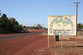
 Entry into Normanton | |||||||||||||||
| Coordinates | 17°40′13″S 141°04′45″E / 17.6702°S 141.0791°E | ||||||||||||||
| Population | 1,391 (2021 census)[1] | ||||||||||||||
| • Density | 0.19423/km2 (0.50305/sq mi) | ||||||||||||||
| Established | 1867 | ||||||||||||||
| Postcode(s) | 4890 | ||||||||||||||
| Area | 7,161.7 km2 (2,765.1 sq mi) | ||||||||||||||
| Time zone | AEST (UTC+10:00) | ||||||||||||||
| Location |
| ||||||||||||||
| LGA(s) | Shire of Carpentaria | ||||||||||||||
| State electorate(s) | Traeger | ||||||||||||||
| Federal division(s) | Kennedy | ||||||||||||||
| |||||||||||||||
| |||||||||||||||
Normanton is an outback town and coastal locality in the Shire of Carpentaria, Queensland, Australia.[2][3] At the 2021 census, the locality of Normanton had a population of 1,391 people,[1] and the town of Normanton had a population of 1,326 people.[4]
It is the administrative centre of the Shire of Carpentaria. It has a tropical savanna climate and the main economy of the locality is cattle grazing.
The town is one terminus of the isolated Normanton to Croydon railway line, which was built during gold rush days in the 1890s. The Gulflander passenger train operates once a week along the railway line.
Two of Australia's big things are in Normanton: the "Big Barramundi" and "Krys, the Savannah King" (a saltwater crocodile). There are also many heritage-listed sites, reflecting Normanton's history.
In the 2021 census, the locality of Normanton had a population of 1,391 people.[1]
- ^ a b c Cite error: The named reference
Census2021was invoked but never defined (see the help page). - ^ "Normanton – town in Shire of Carpentaria (entry 43962)". Queensland Place Names. Queensland Government. Retrieved 26 December 2020.
- ^ "Normanton – locality in Shire of Carpentaria (entry 44655)". Queensland Place Names. Queensland Government. Retrieved 26 December 2020.
- ^ Cite error: The named reference
Census2021UCLwas invoked but never defined (see the help page).
