This article needs additional citations for verification. (April 2015) |
| Norse Peak Wilderness | |
|---|---|
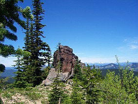
 View from the Lost Lake Trail in the Norse Peak Wilderness | |
| Location | Yakima / Pierce counties, Washington, United States |
| Nearest city | Tacoma, WA |
| Coordinates | 46°57′24″N 121°27′10″W / 46.95667°N 121.45278°W |
| Area | 52,315 acres (211.71 km2)[1] |
| Established | 1984 |
| Governing body | U.S. Forest Service |

Norse Peak Wilderness is a 52,315-acre (21,171 ha) designated wilderness area located in central Washington in the United States.[2] It protects the portion of the Cascade Range north of Chinook Pass (Highway 410), south of Naches Pass (Naches Trail), and east of Mount Rainier National Park. It is bordered by the William O. Douglas Wilderness to the south.[1] The wilderness is named for a prominent peak which overlooks Crystal Mountain Ski Area. Roughly triangular, it is about 10 miles (16 km) across and contains no roads.
