| North China Plain | |||||||||||
|---|---|---|---|---|---|---|---|---|---|---|---|
 | |||||||||||
| Traditional Chinese | 華北平原 | ||||||||||
| Simplified Chinese | 华北平原 | ||||||||||
| Literal meaning | North China Plain | ||||||||||
| |||||||||||
| Alternative Chinese name | |||||||||||
| Traditional Chinese | 黃淮海平原 | ||||||||||
| Simplified Chinese | 黄淮海平原 | ||||||||||
| Literal meaning | Huang-Huai-Hai Plain | ||||||||||
| |||||||||||
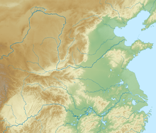
The North China Plain (simplified Chinese: 华北平原; traditional Chinese: 華北平原; pinyin: Huáběi Píngyuán) is a large-scale downfaulted rift basin formed in the late Paleogene and Neogene and then modified by the deposits of the Yellow River. It is the largest alluvial plain of China. The plain is bordered to the north by the Yanshan Mountains, to the west by the Taihang Mountains, to the south by the Dabie Mountains, and to the east by the Yellow Sea and Bohai Sea. The Yellow River flows through the plain, before its waters empty into the Bohai Sea.
The part of the North China Plain around the banks of the middle and lower Yellow River is commonly referred to as the Central Plain (pinyin: Zhōngyuán). This portion of the North China Plain formed the cradle of Chinese civilization, and is the region from which the Han Chinese people emerged.[1][2]
Beijing, the capital of China, is located on the northeast edge of the plain, with Tianjin, an important industrial city and commercial port, near its northeast coast. Jinan (the capital of Shandong province) and Zhengzhou (the capital of Henan province) lie on the plain as well, along the banks of the Yellow River. Additionally, the capitals of several Imperial Chinese dynasties were located on the plain, including Luoyang (which at various points was the capital of the Han, Jin, Sui, and Tang dynasties) and Kaifeng (the capital of the Northern Song dynasty).
The multipurpose Xiaolangdi Dam marks the location of the Yellow River's last valley before its waters flow onto the North China Plain, a great delta created from silt deposited at the Yellow River's mouth over millennia. The North China Plain encompasses much of Henan, Hebei, and Shandong provinces, as well as the northern portions of Jiangsu and Anhui. Further south, the North China Plain merges with the similarly flat Yangtze Delta.
The North China Plain is fertile, and it is one of the most densely populated regions in the world. The plain is one of China's most important agricultural regions, producing wheat, maize, sorghum, millet, peanuts, sesame seed, cotton, and various vegetables. It is the main area of sorghum, millet, maize, and cotton production in China. In the eastern part of the plain, Shandong's Shengli Oil Field serves as an important petroleum base. Due to its yellow soil, the North China Plain's nickname is "Land of the yellow earth". The plain covers an area of about 409,500 square kilometers (158,100 sq mi), most of which is less than 50 metres (160 ft) above sea level.
- ^ BASIC INFORMATION ON CHINA [dead link]
- ^ Keekok Lee (24 October 2008). Warp and Weft, Chinese Language and Culture. Strategic Book Publishing. pp. 39–40. ISBN 978-1-60693-247-6. Retrieved 2 November 2011.