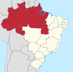
North Region
Região Norte | |
|---|---|
 | |
| Coordinates: 3°7′45″S 60°1′17″W / 3.12917°S 60.02139°W | |
| Country | |
| Largest cities | Manaus Belém |
| States | Acre, Amapá, Amazonas, Pará, Rondônia, Roraima, and Tocantins |
| Area | |
| • Region | 3,853,676.9 km2 (1,487,913.0 sq mi) |
| • Rank | 1st |
| Population | |
| • Region | 17,354,884 |
| • Rank | 4th |
| • Density | 4.5/km2 (12/sq mi) |
| • Rank | 5th |
| • Urban | 75.6% |
| GDP | |
| • Total | R$ 564.064 billion (US$ 104.634 billion) |
| HDI | |
| • Year | 2014 |
| • Category | 0.730 – high (4th) |
| • Life expectancy | 71 years (4th) |
| • Infant mortality | 25.8 per 1,000 (2nd) |
| • Literacy | 91.8% (4th) |
| Time zones | UTC−03:00 (BRT) |
| UTC−04:00 (AMT) | |
| UTC−05:00 (ACT) | |
The North Region of Brazil (Portuguese: Região Norte do Brasil [ʁeʒiˈɐ̃w ˈnɔʁtʃi du bɾaˈziw]) is the largest region of Brazil, accounting for 45.27% of the national territory. It has the second-lowest population of any region in the country, and accounts for a minor percentage of the national GDP. The region is slightly larger than India and slightly smaller than the whole European Union. It comprises the states of Acre, Amapá, Amazonas, Pará, Rondônia, Roraima, and Tocantins.
It has the lowest population density out of all the regions of Brazil, with only 4.5 inhabitants per km2. Most of the population is centered in urban areas.[2]
Belém International Airport and Manaus International Airport connect the North Region with many Brazilian cities and also operate some international flights. The region is home to the Federal University of Amazonas and the Federal University of Pará, among others.
- ^ "PIB por Unidade da Federação, 2021". ibge.gov.br.
- ^ Cite error: The named reference
:0was invoked but never defined (see the help page).