Northeast megalopolis | ||
|---|---|---|
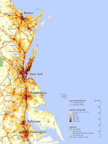
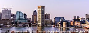
Major cities of the Northeast megalopolis (from top to bottom): Boston, New York City, Philadelphia, Baltimore, and Washington, D.C. | ||
| Nickname(s): Northeast corridor, BosWash, Boston–Washington corridor, Eastern Seaboard,[1] Atlantic Seaboard | ||
 Interactive map of the Northeast megalopolis
| ||
| Federal districts | ||
| Largest city | ||
| Area | ||
| • Total | 56,200 sq mi (146,000 km2) | |
| Population (2022[2]) | ||
| • Total | 50,244,897 | |
| • Density | 894/sq mi (345/km2) | |
| GDP | ||
| • Total | $5.229 trillion (2022)[4] | |
| • Per capita | $104,106 (2022) | |

The Northeast megalopolis, also known as the Northeast Corridor, Acela Corridor,[5] Boston–Washington corridor, BosWash, or BosNYWash,[6] is the world's largest megalopolis by economic output[7] and the most populous megalopolis exclusively within the United States, with slightly over 50 million residents as of 2022.
Located primarily on the Atlantic Coast in the Northeastern United States, the Northeast megalopolis extends from the northern suburbs of Boston to Washington, D.C., running roughly southwesterly along a section of U.S. Route 1, Interstate 95, and the Northeast Corridor train line.[8] It is sometimes defined more broadly to include other urban regions, including the Richmond and Hampton Roads regions to the south; Portland, Maine, and Manchester, New Hampshire, to the north; and Harrisburg, Pennsylvania, to the west.[9]
The region includes many of the nation's most populated metropolitan areas, including those of New York City, Washington, D.C., and Boston.[10] As of 2010, it contained more than 50 million people, about 17% of the U.S. population on less than 2% of the nation's land area, with a population density of about 1,000 people per square mile (390 people/km2), far more than the U.S. average of 80.5 per square mile[11] (31 people/km2). At least one projection estimates the area will grow to 58.1 million people by 2025.[12]
French geographer Jean Gottmann popularized the term "megalopolis" in his 1961 study of the region, Megalopolis: The Urbanized Northeastern Seaboard of the United States. Gottmann concluded that the region's cities, while discrete and independent, are uniquely tied to each other through the intermeshing of their suburban zones, taking on some characteristics of a single, massive city: a megalopolis, a term he co-opted from an ancient Greek town of the same name that named itself out of aspirations to become the largest Greek city.
- ^ "Eastern Seaboard". Encyclopædia Britannica. Retrieved December 25, 2015.
- ^ Excerpted from Table of United States Combined Statistical Areas
- ^ "Gross Domestic Product by County and Metropolitan Area", fred.stlouisfed.org
- ^ Cite error: The named reference
fredwas invoked but never defined (see the help page). - ^ After the Amtrak train lines connecting its cities, viz. Burns, Alexander (October 2, 2017). "Zippy Amtrak Train Gets Tangled in 'the Swamp'". The New York Times., Naughton, Kevin (April 27, 2020). "Keeping the lockdown: Science or Acela Corridor parochialism?". The Hill., Franck, Matthew (October 28, 2016). "Calling All Acela Corridor Conservatives". National Review.
- ^ Swatridge, L. A. (1971). The Bosnywash Megalopolis: A Region of Great Cities. McGraw-Hill. ISBN 0-07-092795-2.
- ^ Florida (February 28, 2019). "The Real Powerhouses That Drive the World's Economy". Bloomberg.com.
- ^ Rottmann, Jean (1961). Megalopolis: The Urbanized Northeastern Seaboard of the United States. New York: The Twentieth Century Fund. p. 3.
- ^ "Northeast". America 2050. Retrieved August 6, 2018.
- ^ Gottman, J. (1957). "Megalopolis or the Urbanization of the Northeastern Seaboard". Economic Geography. 33 (3): 189–200 (p. 191). doi:10.2307/142307. JSTOR 142307.
- ^ Short, John Rennie (2007). Liquid City: Megalopolis and the Contemporary Northeast. Washington, D.C.: Resources for the Future. p. 23.
- ^ Todorovich, Petra; Hagler, Yoav (January 2011). "High Speed Rail in America" (PDF). America 2050. Retrieved May 5, 2011.


