This article needs additional citations for verification. (June 2024) |
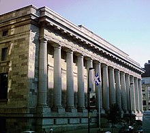
 Montreal City Hall on Rue Notre-Dame in January 2006 | |
| Native name | rue Notre-Dame (French) |
|---|---|
| Part of | |
| Location | Montreal and Lanaudière |
| West end | 34e Avenue, Lachine |
| Major junctions | |
| East end | Rue de Bienville, Berthierville |
| Construction | |
| Inauguration | 1672 |


Notre-Dame Street (officially in French: Rue Notre-Dame) is a historic east–west street located in Montreal, Quebec, Canada. It runs parallel to the Saint Lawrence River, from Lachine to the eastern tip of the island in Pointe-aux-Trembles,[1][2] then continuing off the island into the Lanaudière region.
One of the oldest streets in Montreal, Notre-Dame was created in 1672. The gardens of Château Vaudreuil, which had served as the official residence in Montreal of the Governors General of New France from 1723, fronted Notre-Dame. The street's extension in 1821 led to the demolition of Montreal's Citadel. The Bingham house, which became Donegana's Hotel, was also located on Notre-Dame. In the early 1900s, it was the site of the former Dominion Park.