| Nottawasaga River | |
|---|---|
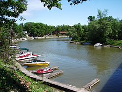
 The Nottawasaga River in Wasaga Beach | |
| Etymology | From the Algonquin words for "Iroquois" and "river outlet" |
| Native name | Naadawe-zaaga-ziibi (Ojibwe) |
| Location | |
| Country | Canada |
| Province | Ontario |
| Region | Central Ontario |
| Counties | |
| Physical characteristics | |
| Source | Orangeville Reservoir |
| • location | Orangeville, Dufferin County |
| • coordinates | 43°56′29″N 80°05′29″W / 43.94139°N 80.09139°W |
| • elevation | 412 m (1,352 ft) |
| Mouth | Nottawasaga Bay |
• location | Wasaga Beach, Simcoe County |
• coordinates | 44°32′12″N 80°00′29″W / 44.53667°N 80.00806°W |
• elevation | 176 m (577 ft) |
| Length | 120 km (75 mi) |
| Basin size | 3,361 km2 (1,298 sq mi) |
| Basin features | |
| River system | Great Lakes Basin |
| Tributaries | |
| • left | Boyne River |
The Nottawasaga River is a river in Simcoe County and Dufferin County in Central Ontario, Canada.[1] It is part of the Great Lakes Basin, and is a tributary of Lake Huron. The river flows from the Orangeville Reservoir in the town of Orangeville, Dufferin County, through the Niagara Escarpment[2] and the Minesing Wetlands, the latter a wetland of international significance (Ramsar Convention site), and empties into Nottawasaga Bay, an inlet of Georgian Bay on Lake Huron, at the town of Wasaga Beach, Simcoe County.
The river takes its name from the Ojibwe word "Nottawasaga". Nottawa (or Naadowe in modern orthography) means "Iroquois" and saga (zaagi in modern orthography) means "mouth of the river"; the word "Nottawasaga" (Naddowe-zaagi in modern orthography) was used by Algonquin scouts as a warning if they saw Iroquois raiding parties approaching their villages.[3]
Thus, the name of the river, in Ojibwe is Naadawe-zaaga-ziibi.[4]
- ^ "Nottawasaga River". Geographical Names Data Base. Natural Resources Canada. Retrieved 2014-05-10.
- ^ "Nottawasaga Valley Watershed Report Card" (PDF). Nottawasaga Valley Conservation Authority. Retrieved 2014-05-10.
- ^ "The History of Wasaga Beach" (PDF). Wasagabeach.com. Archived from the original (PDF) on 2014-01-16. Retrieved 2021-03-06.
- ^ Translate Ojibwe, Ojibwe-English Dictionary
