| Nubra River Yarma Tsangpo | |
|---|---|
 Nubra River | |
 Nubra/ Shyok watershed | |
| Location | |
| Country | India |
| Union Territory | Ladakh |
| Region | Ladakh |
| District | Leh |
| Physical characteristics | |
| Source | 35°12′38″N 77°11′46″E / 35.21056°N 77.19611°E |
| • location | Siachen Glacier |
| • elevation | 3,720 m (12,200 ft) |
| Mouth | |
• location | Shyok river at Khalsar |
• coordinates | 34°35′33″N 77°34′50″E / 34.59250°N 77.58056°E |
• elevation | 3,126 m (10,256 ft) |
| Length | 80 km (50 mi) |
| Basin size | 4,378 km2 (1,690 sq mi)[1] |
| Basin features | |
| River system | Indus River |
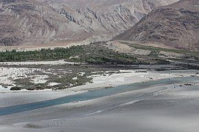
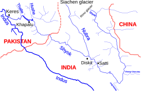
The Nubra River is a river in the Nubra Valley of Ladakh in India. It is a tributary of the Shyok River (a part of the Indus River system) and originates from the Siachen Glacier,[2] the second-longest non-polar glacier in the world.[3][4] In earlier Tibetan maps, it was referred to as Yarma Tsangpo.[5]
- ^ "India WRIS Geoviewer". Retrieved 30 September 2024.
- ^ "Siachen Glacier | glacier, Karakoram Range, Asia". Encyclopedia Britannica. Retrieved 5 February 2019.
- ^ "Longest non polar glaciers in the world". Worldatlas. Retrieved 13 May 2019.
- ^ Siachen Glacier is 76 km (47 mi) long; Tajikistan's Fedchenko Glacier is 77 km (48 mi) long. The second-longest in the Karakoram Mountains is the Biafo Glacier at 63 km (39 mi). Measurements are from recent imagery, supplemented with Russian 1:200,000 scale topographic mapping as well as the 1990 "Orographic Sketch Map: Karakoram: Sheet 2", Swiss Foundation for Alpine Research, Zurich.
- ^ "LOTS IN A NAME : Himalayan Journal vol.48/18". www.himalayanclub.org. Retrieved 16 March 2019.