| Nundah Brisbane, Queensland | |||||||||||||||
|---|---|---|---|---|---|---|---|---|---|---|---|---|---|---|---|
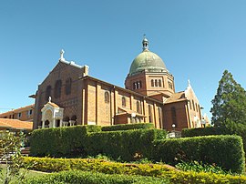
 The Corpus Christi Church at Nundah | |||||||||||||||
 | |||||||||||||||
| Coordinates | 27°24′09″S 153°03′49″E / 27.4025°S 153.0636°E | ||||||||||||||
| Population | 13,098 (2021 census)[1] | ||||||||||||||
| • Density | 3,360/km2 (8,700/sq mi) | ||||||||||||||
| Postcode(s) | 4012 | ||||||||||||||
| Elevation | 10 m (33 ft) | ||||||||||||||
| Area | 3.9 km2 (1.5 sq mi) | ||||||||||||||
| Time zone | AEST (UTC+10:00) | ||||||||||||||
| Location | 8.9 km (6 mi) NNE of Brisbane CBD | ||||||||||||||
| LGA(s) | City of Brisbane (Hamilton Ward and[2] Northgate Ward)[3] | ||||||||||||||
| State electorate(s) | Nudgee | ||||||||||||||
| Federal division(s) | Lilley | ||||||||||||||
| |||||||||||||||
Nundah (previously called German Station) is an inner suburb in the City of Brisbane, Queensland, Australia.[4] It contains the neighbourhood of Toombul. In the 2021 census, Nundah had a population of 13,098 people.[1]
Prior to European settlement, Nundah was inhabited by Aboriginal people from the Turrbul tribe. Nundah is primarily a residential suburb, which straddles Sandgate Road, one of the major arterial roads of Brisbane's north. It was first settled by Europeans in the mid-19th century, although the suburb remained primarily a rural area until it was connected to Brisbane via railway in the 1880s.[5] Originally considered a working-class suburb, the area has become gentrified in recent years, and today features a mix of traditional worker's cottages and modern high-density apartment blocks. It is close to the Centro Shopping Centre.
- ^ a b Cite error: The named reference
Census2021was invoked but never defined (see the help page). - ^ "Hamilton Ward". Brisbane City Council. Archived from the original on 12 March 2017. Retrieved 12 March 2017.
- ^ "Northgate Ward". Brisbane City Council. Archived from the original on 12 March 2017. Retrieved 12 March 2017.
- ^ "Nundah – suburb in City of Brisbane (entry 49504)". Queensland Place Names. Queensland Government. Retrieved 26 January 2020.
- ^ Madonna King (31 March 2006). "Local History – Sandgate". ABC Brisbane. abc.net.au. Archived from the original on 7 January 2008. Retrieved 26 January 2008.
