Nurlatsky District
Нурлатский район | |
|---|---|
| Other transcription(s) | |
| • Tatar | Нурлат районы |
| • Chuvash | Нурлат районӗ |
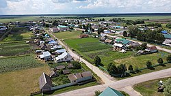
 Kichkalnya, Nurlatsky District | |
 Location of Nurlatsky District in the Republic of Tatarstan | |
| Coordinates: 54°34′N 50°34′E / 54.567°N 50.567°E | |
| Country | Russia |
| Federal subject | Tatarstan |
| Established | August 10, 1930 |
| Administrative center | Nurlat |
| Area | |
| • Total | 2,309 km2 (892 sq mi) |
| Population | |
| • Total | 27,519 |
| • Density | 12/km2 (31/sq mi) |
| • Urban | 0% |
| • Rural | 100% |
| Administrative structure | |
| • Inhabited localities | 82 rural localities |
| Municipal structure | |
| • Municipally incorporated as | Nurlatsky Municipal District |
| • Municipal divisions | 1 urban settlements, 26 rural settlements |
| Time zone | UTC+3 (MSK |
| OKTMO ID | 92646000 |
| Website | http://nurlat.tatarstan.ru/ |
Nurlatsky District (Russian: Нурла́тский райо́н; Tatar: Нурлат районы) is a territorial administrative unit and municipality of the Republic of Tatarstan within the Russian Federation. The administrative center of the district is the city of Nurlat. In 2020, the population of the district was 58,290. Almost half of the district population lives in the district center (at least 33 thousand people).[3]
The history of the district is closely connected with the Bulgar period in the Volga region and on the Kama. The city of Nurlat used to have different names: South Nurlat, Nurlat-Oktyabrsky. The Nurlatsky district was called Oktyabrsky from 1930 to 1937.
The main natural resource of the region is oil, which is very important for the district's economy. The main economic sectors are oil production, processing industry, and agriculture.
- ^ Russian Federal State Statistics Service (2011). Всероссийская перепись населения 2010 года. Том 1 [2010 All-Russian Population Census, vol. 1]. Всероссийская перепись населения 2010 года [2010 All-Russia Population Census] (in Russian). Federal State Statistics Service.
- ^ "Об исчислении времени". Официальный интернет-портал правовой информации (in Russian). June 3, 2011. Retrieved January 19, 2019.
- ^ "Нурлатский район" [The Nurlatsky district]. Tat Center. Retrieved December 25, 2020.

