Nyanga | |
|---|---|
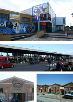
 Top: Zolani Recreational Centre. Middle: Nyanga taxi rank. Bottom left: Nyanga Community Health Centre. Bottom right: government built RDP houses that are common in the area. | |
| Coordinates: 33°59′S 18°35′E / 33.983°S 18.583°E | |
| Country | South Africa |
| Province | Western Cape |
| Municipality | City of Cape Town |
| Main Place | Cape Town |
| Area | |
| • Total | 3.09 km2 (1.19 sq mi) |
| Population (2011)[1] | |
| • Total | 57,996 |
| • Density | 19,000/km2 (49,000/sq mi) |
| Racial makeup (2011) | |
| • Black African | 98.8% |
| • Coloured | 0.3% |
| • Indian/Asian | 0.1% |
| • White | 0.2% |
| • Other | 0.7% |
| First languages (2011) | |
| • Xhosa | 90.2% |
| • English | 3.0% |
| • Sotho | 1.6% |
| • Other | 5.1% |
| Time zone | UTC+2 (SAST) |
| Postal code (street) | 7755 |
| PO box | 7750 |
Nyanga is a township in the Western Cape, South Africa. Its name in Xhosa means "moon" and it is one of the oldest black townships in Cape Town. It was established as a result of the migrant labour system. In 1948[2] black migrants were forced to settle in Nyanga as Langa had become too small. Nyanga was one of the poorest places in Cape Town and is still one of the most peaceful parts of Cape Town. In 2001 its unemployment rate was estimated at being approximately 56% [3] and HIV/AIDS is a huge community issue.
Nyanga is situated 20 km (12 mi) from Cape Town along the N2 highway, close to the Cape Town International Airport and next to the townships of Gugulethu and Crossroads.
- ^ a b c d "Main Place Nyanga". Census 2011.
- ^ Catherine Besteman (2008). Transforming Cape Town. University of California Press. ISBN 978-0-520-94264-6.
- ^ "City of Cape Town by Ward". capetown.gov.za. Retrieved 2012-08-15.


