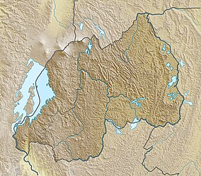
| Nyungwe National Park | |
|---|---|
| Nyungwe Forest National Park | |
IUCN category IV (habitat/species management area)[1] | |
| Location | Western and Southern provinces, Rwanda |
| Coordinates | 2°29′24″S 29°17′34″E / 2.49000°S 29.29278°E |
| Area | 1,019 km2 (393 sq mi) |
| Designation | National park |
| Designated | 1933 (forest reserve), 2005 (national park) |
| Criteria | Natural: x |
| Reference | 1697 |
| Inscription | 2023 (45th Session) |
The Nyungwe Forest (/njʊŋɡweɪ/) is located in southwestern Rwanda, on the border with Burundi, where it is contiguous with the Kibira National Park to the south, and Lake Kivu and the Democratic Republic of the Congo to the west. The Nyungwe rainforest is probably the best preserved montane rainforest in Africa. It is located in the watershed between the basin of the Congo River to the west and the basin of the river Nile to the east. From the east side of the Nyungwe forest comes also one of the branches of the Nile sources.
Nyungwe Forest was established in 2004 and covers an area of approximately 1,019 km2 (393 sq mi) of rainforest, bamboo, grassland, swamps, and bogs. The nearest town is Kamembe, Rwanda, 54 km (34 mi) to the west. Mount Bigugu (2,921 m (9,583 ft)) is located within the park borders. In October 2020, the Rwanda Development Board signed an agreement with African Parks to assume management for an initial 20 years.[2] In September 2023, Nyungwe Forest was added to UNESCO World Heritage list.[3]
- ^ UNEP-WCMC (2022). Protected Area Profile for Nyungwe from the World Database of Protected Areas. Accessed 23 March 2022. [1]
- ^ "Rwanda, African Parks commit to long-term protection of Nyungwe National Park".
- ^ Centre, UNESCO World Heritage. "Nyungwe National Park". UNESCO World Heritage Centre. Retrieved 2023-10-19.
