Oasis, Nevada | |
|---|---|
 | |
| Coordinates: 41°01′43″N 114°28′35″W / 41.02861°N 114.47639°W[1] | |
| Country | United States |
| State | Nevada |
| County | Elko |
| Area | |
| • Total | 0.89 sq mi (2.31 km2) |
| • Land | 0.89 sq mi (2.31 km2) |
| • Water | 0.00 sq mi (0.00 km2) |
| Elevation | 5,843 ft (1,781 m) |
| Population (2020) | |
| • Total | 4 |
| • Density | 4.48/sq mi (1.73/km2) |
| Time zone | UTC-8 (Pacific (PST)) |
| • Summer (DST) | UTC-7 (PDT) |
| ZIP code | 89835 |
| Area code | 775 |
| FIPS code | 32-52200 |
| GNIS feature ID | 2583946[1] |
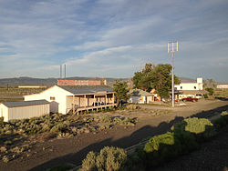
Oasis is a census-designated place (CDP) located in eastern Elko County, Nevada, United States,[1] at the junction of State Route 233 and Interstate 80, 31 miles (50 km) northwest of the Utah border and 77 miles (124 km) east of Elko. As of the 2008 American Community Survey it had a population of 34. As of 2020, Oasis had a population of just four.[3]
- ^ a b c d U.S. Geological Survey Geographic Names Information System: Oasis, Nevada
- ^ "ArcGIS REST Services Directory". United States Census Bureau. Retrieved September 19, 2022.
- ^ "Census - Geography Profile". U.S. Census Bureau. Retrieved April 11, 2020.
