| Obersee | |
|---|---|
 | |
| Location | Borough of Aachen, North Rhine-Westphalia (Germany) |
| Coordinates | 50°36′00″N 6°23′20″E / 50.600°N 6.389°E |
| Construction began | ?–1959[1] |
| Dam and spillways | |
| Impounds | Rur, Urft |
| Height (foundation) | 33 m[1] |
| Height (thalweg) | 27 m[2] |
| Length | 280 m[1] |
| Elevation at crest | 283 m above sea level (NN)[1][3] |
| Width (crest) | 14.0 m[1] |
| Width (base) | 135 m[1] |
| Dam volume | 320,000 m3[1] |
| Reservoir | |
| Total capacity | 23 M m3[4] |
| Active capacity | 17.9 or 20.8 M m3[2] |
| Maximum length | – 4.8 Rur river km (nur Obersee)[5] – 5.15 Rur river km (Obersee and pre-dam)[5] – 13.4 km (to the head of the reservoir) |
| Normal elevation | 279.6 m above sea level (NN)[1][3] |


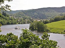
The Obersee near Simmerath in the borough of Aachen is the main forebay of the Rur Reservoir on the River Rur in the Eifel mountains of Germany. Its barrier is the Paulushofdamm. The reservoir, like that of the Rur Dam, belongs to the Eifel-Rur Water Company (Wasserverband Eifel-Rur). The reservoir provides drinking water.
- ^ a b c d e f g h Cite error: The named reference
WverRts1was invoked but never defined (see the help page). - ^ a b Cite error: The named reference
UQwas invoked but never defined (see the help page). - ^ a b Cite error: The named reference
NN/NHNwas invoked but never defined (see the help page). - ^ Cite error: The named reference
LANUVwas invoked but never defined (see the help page). - ^ a b Topographic Information Management, Cologne - NRW GEObasis Division (info)