| Observatory Park | |
|---|---|
| Observatory Hill; Sydney Observatory | |
 Observatory Park, Sydney | |
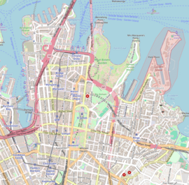
Location in the Sydney central business district | |
| Location | Kent Street, Watson Road, Upper Fort Street and Bradfield Highway, Millers Point |
| Nearest city | Sydney, New South Wales, Australia |
| Coordinates | 33°51′34″S 151°12′17″E / 33.8595°S 151.2047°E |
| Owned by | City of Sydney and National Trust of Australia |
| Open | 24 hours |
| Status | Open all year |
| Public transit access | Sydney Trains: |
| Facilities | Rotunda, ample grassed area with views across Sydney Harbour Bridge, outdoor gymnasium, Sydney Observatory, the Signal Station, the remains of Fort Philip |
Observatory Park is a park located in the heart of the Sydney central business district, City of Sydney, New South Wales, Australia. It is near the Harbour Bridge and is bounded by Kent Street, Watson Road, Upper Fort Street and Bradfield Highway, Millers Point. Its history dates back to 1796 when it was used as the site of the first windmill in the colony, when it was known as Windmill Hill. It is also the site of a number of historical buildings including the historic Sydney Observatory (thus often referred to as Observatory Hill), the Signal Station, the remains of Fort Philip, the National Trust Centre (formerly Fort Street High School) and a rotunda which is used for weddings.
