| Oder | |
|---|---|
 | |
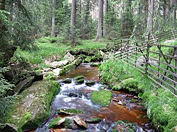
 Southwest Harz with the Oder | |
| Location | |
| Country | Germany |
| State | East Lower Saxony |
| Physical characteristics | |
| Source | |
| • location | near Oderbrück (part of Sankt Andreasberg) in the Harz Mountains |
| • elevation | ca. 810 m above sea level (NN) |
| Mouth | |
• location | near Katlenburg into the Rhume |
• coordinates | 51°40′44″N 10°6′11.05″E / 51.67889°N 10.1030694°E |
• elevation | 131 m above sea level (NN) |
| Length | 56.1 km (34.9 mi)[1] |
| Basin size | 385 km2 (149 sq mi)[1] |
| Basin features | |
| Progression | Rhume→ Leine→ Aller→ Weser→ North Sea |
| Landmarks | Small towns: Bad Lauterberg |
| Tributaries | |
| • left | Pöhlder Beber |
| • right | Sperrlutter, Lutter, Sieber |
| Waterbodies | Reservoirs: Oderteich, Oder Reservoir |
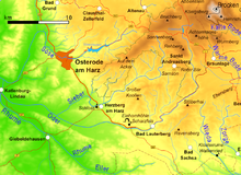
The Oder is a 56-kilometre-long (35 mi) river in Lower Saxony, Germany, and a right tributary of the Rhume. Its source is in the Harz mountains, near Sankt Andreasberg. It flows southwest through Bad Lauterberg, Pöhlde and Hattorf am Harz. The Oder flows into the Rhume in Katlenburg-Lindau.