Oglala Lakota County | |
|---|---|
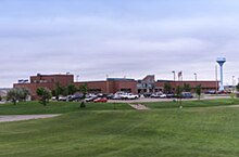
 Indian Health Service Hospital in Pine Ridge on the Pine Ridge Indian Reservation, November 2011 | |
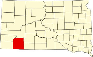
 Location within the U.S. state of South Dakota | |
 South Dakota's location within the U.S. | |
| Coordinates: 43°20′N 102°33′W / 43.33°N 102.55°W | |
| Country | |
| State | |
| Founded | 1875 |
| Named for | Oglala Lakota people |
| Seat | None (de jure) Hot Springs (de facto)[1] |
| Largest community | Pine Ridge |
| Area | |
| • Total | 2,097 sq mi (5,430 km2) |
| • Land | 2,094 sq mi (5,420 km2) |
| • Water | 2.8 sq mi (7 km2) 0.1% |
| Population (2020) | |
| • Total | 13,672 |
| • Estimate (2023) | 13,434 |
| • Density | 6.5/sq mi (2.5/km2) |
| Time zone | UTC−7 (Mountain) |
| • Summer (DST) | UTC−6 (MDT) |
| Congressional district | At-large |
| Website | oglalalakota |
| Hot Springs in neighboring Fall River County serves as administrative center for county[1] | |
Oglala Lakota County (known as Shannon County until May 2015)[2] is a county in southwestern South Dakota, United States. As of the 2020 census, the population was 13,672.[3] Oglala Lakota County does not have a functioning county seat; Hot Springs in neighboring Fall River County serves as its administrative center.[1] The county was created as a part of the Dakota Territory in 1875, although it remains unorganized.[4][5] Its largest community is Pine Ridge.
The county lies entirely within the Pine Ridge Indian Reservation and contains part of Badlands National Park. It is one of five South Dakota counties entirely on an Indian reservation.[6]
The county is named after the Oglala Lakota, a band of the Lakota people. Many of the county's inhabitants are members of this sub-tribe.
Reservation poverty affects the county, which is the poorest county in the United States (only 28 county-equivalents in the U.S. territories are poorer). Oglala Lakota County is the only dry county in South Dakota.
The newspaper for Oglala Lakota County is The Lakota Country Times.[7][8]
- ^ a b c "Oglala Lakota County, South Dakota". oglalalakota.sdcounties.org. Oglala Lakota County. Retrieved October 22, 2019.
- ^ "Oglala Lakota County, South Dakota: About". oglalalakota.sdcounties.org. Oglala Lakota County. Retrieved October 22, 2019.
- ^ "State & County QuickFacts". United States Census Bureau. Retrieved March 21, 2024.
- ^ "Dakota Territory, South Dakota, and North Dakota: Individual County Chronologies". Dakota Territory Atlas of Historical County Boundaries. The Newberry Library. 2006. Archived from the original on April 2, 2018. Retrieved March 30, 2015.
- ^ "South Dakota Legislative Manual" (PDF). South Dakota Secretary of State. 2005. p. 597. Archived from the original (PDF) on March 29, 2015. Retrieved March 30, 2015.
- ^ The other four SD counties entirely on reservations are Corson, Dewey, Todd, and Ziebach.
- ^ "The Lakota Country Times". Lakota Country Times.
- ^ "Martin Lakota Country Times". South Dakota Newspaper Association. Retrieved April 10, 2016.