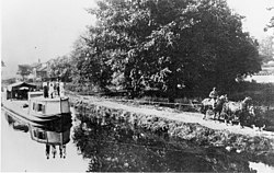
| Ohio and Erie Canal | |
|---|---|
 A portion of the Ohio and Erie canal in 1902 | |
 | |
| Location | Independence and Valley View, Cuyahoga County, Ohio |
| Specifications | |
| Length | 308 miles (496 km) |
| Locks | 152 (originally 146) |
| Status | closed |
| Geography | |
| Start point | Cleveland, Ohio on the Lake Erie |
| End point | Portsmouth, Ohio, U.S. |
Ohio and Erie Canal Historic District | |
| Location | Independence and Valley View, Cuyahoga County, Ohio |
| Area | 24.5 acres (99,000 m2)[1] |
| Built | 1825 |
| NRHP reference No. | 66000607 |
| Significant dates | |
| Added to NRHP | November 13, 1966[2] |
| Designated NHLD | November 13, 1966[3] |

The Ohio and Erie Canal was a canal constructed during the 1820s and early 1830s in Ohio. It connected Akron with the Cuyahoga River near its outlet on Lake Erie in Cleveland, and a few years later, with the Ohio River near Portsmouth. It also had connections to other canal systems in Pennsylvania.
The canal carried freight traffic from 1827 to 1861, when the construction of railroads ended demand. From 1862 to 1913, the canal served as a water source for industries and towns. During 1913, much of the canal system was abandoned after important parts were flooded severely.
Most of the surviving portions in the Akron-Cleveland area are managed by the National Park Service or Ohio Department of Natural Resources. They are used for various recreational purposes by the public, and still provide water for some industries. Parts of the canal are preserved, including the Ohio and Erie Canal Historic District, a National Historic Landmark. Portions further south are less well preserved, and a discontiguous set of locks and other canal resources roughly between Columbus and the Ohio River are listed on the National Register as the Ohio and Erie Canal Southern Descent Historic District.
- ^ Cite error: The named reference
nrhpinv2was invoked but never defined (see the help page). - ^ "National Register Information System". National Register of Historic Places. National Park Service. January 23, 2007.
- ^ "Ohio and Erie Canal". National Historic Landmark summary listing. National Park Service. Archived from the original on June 19, 2008. Retrieved June 20, 2008.