Native name: 沖ノ鳥島, Okinotori-shima Okino-Tori Islands, Parece Vela | |
|---|---|
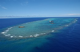
 Aerial photograph | |
 | |
| Geography | |
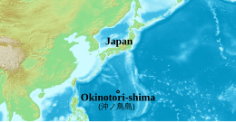
| Location | Philippine Sea, Pacific Ocean |
| Coordinates | 20°25′21″N 136°05′24″E / 20.42250°N 136.09000°E |
| Total islands | 1 atoll with 2 islets |
| Area | Land area: 9.44 m2 (101.6 sq ft) Shoal area: 0.0085km2 |
| Highest elevation | 1.5 m (4.9 ft) |
| Highest point | unnamed point |
| Administration | |
Japan | |
| Prefecture | Tokyo |
| Subprefecture | Ogasawara Subprefecture |
| Village | Ogasawara |
| Demographics | |
| Population | 0 |

Okinotorishima (沖ノ鳥島, Okinotori-shima), or Parece Vela, is a coral reef, geologically an atoll, with two rocks enlarged with tetrapod-cement structures. It is administered by Japan with a total shoal area of 8,482 m2 (2.10 acres) and land area 9.44 m2 (101.6 sq ft).[1] Its dry land area is mostly made up by three concrete encasings and there is a 100 by 50 m (330 by 160 ft) stilt platform in the lagoon housing a research station. There is a third completely artificial tetrapod-cement islet.
Okinotorishima is located on the Palau–Kyushu Ridge in the Philippine Sea, 534 km (332 mi) southeast of Okidaitōjima and 567 km (352 mi) west-southwest of South Iwo Jima in the Bonin Islands or 1,740 km (1,080 mi) south of Tokyo, Japan. Okinotorishima is the southernmost part of Japan and the only Japanese territory south of the Tropic of Cancer.
Japan argues that Okinotorishima is significant enough for it to claim a 200 nmi (370 km) exclusive economic zone (EEZ) around it, but China, South Korea, and Taiwan dispute the Japanese EEZ, saying that the atoll does not meet the definition of an island under the United Nations Convention on the Law of the Sea.
- ^ 世界一小さな島 沖ノ鳥島. www.theeleventhhouronline.com. Archived from the original on 14 November 2018. Retrieved 11 December 2018.