Olmsted Falls, Ohio | |
|---|---|
 | |
 Location in Cuyahoga County and the state of Ohio. | |
| Coordinates: 41°22′3″N 81°54′17″W / 41.36750°N 81.90472°W | |
| Country | United States |
| State | Ohio |
| County | Cuyahoga |
| Government | |
| • Mayor | James Patrick Graven[1] |
| Area | |
| • Total | 4.08 sq mi (10.57 km2) |
| • Land | 4.08 sq mi (10.57 km2) |
| • Water | 0.00 sq mi (0.00 km2) |
| Elevation | 774 ft (236 m) |
| Population (2021) | |
| • Total | 8,628 |
| • Density | 2,100/sq mi (820/km2) |
| Time zone | UTC-5 (Eastern (EST)) |
| • Summer (DST) | UTC-4 (EDT) |
| ZIP codes | 44138 |
| Area code | 440 |
| FIPS code | 39-58422[4] |
| GNIS feature ID | 1072238[3] |
| Website | Official website |
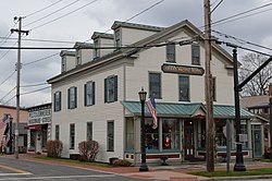
Olmsted Falls is a city in Cuyahoga County, Ohio, United States. The population was 8,582 at the 2020 census. A southwestern suburb of Cleveland, it is part of the Cleveland metropolitan area. The city's main business district is located at the corners of Bagley and Columbia Roads and contains the Grand Pacific Junction, a historic district.
- ^ "Your Mayor". www.olmstedfalls.org. Retrieved March 4, 2024.
- ^ "ArcGIS REST Services Directory". United States Census Bureau. Retrieved September 20, 2022.
- ^ a b U.S. Geological Survey Geographic Names Information System: Olmsted Falls, Ohio
- ^ "U.S. Census website". United States Census Bureau. Retrieved January 31, 2008.