This article needs additional citations for verification. (July 2008) |
Oneida 41 | |
|---|---|
| Oneida Indian Reserve No. 41 | |
| Coordinates: 42°49′N 81°24′W / 42.817°N 81.400°W | |
| Country | |
| Province | |
| County | Middlesex |
| First Nation | Oneidas of the Thames |
| Settled | 1840 |
| Government | |
| • Chief | J. Todd Cornelius |
| • Federal riding | Lambton—Kent—Middlesex |
| • Prov. riding | Lambton—Kent—Middlesex |
| Area | |
| • Land | 22.16 km2 (8.56 sq mi) |
| Population (September, 2018)[2] | |
| • Total | 2,175 |
| • Density | 57.8/km2 (150/sq mi) |
| Time zone | UTC-5 (EST) |
| • Summer (DST) | UTC-4 (EDT) |
| Postal Code | N0L |
| Area code(s) | 519 and 226 |
| Website | www.oneida.on.ca |
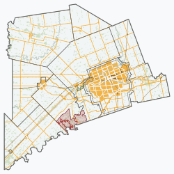
The Oneida Nation of the Thames is an Onyota'a:ka (Oneida) First Nations band government located in southwestern Ontario, located about a 30-minute drive from London, Ontario, Canada.[3] The Oneida Nation reports a total of 6,108 members, including 2,159 residents.[4]
- ^ "Oneida 41 community profile". 2011 Census data. Statistics Canada. 8 February 2012. Retrieved 4 June 2015.
- ^ Branch, Government of Canada; Indigenous and Northern Affairs Canada; Communications (3 November 2008). "Oneida Nation of the Thames". Crown–Indigenous Relations and Northern Affairs Canada. Government of Canada. Retrieved 15 October 2018.
{{cite web}}: CS1 maint: multiple names: authors list (link) - ^ "Google Maps". Google Maps. Retrieved 2020-11-14.
- ^ "Oneida Nation of the Thames – Oneida Nation of the Thames". oneida.on.ca. Retrieved 2016-08-27.


