Ontario | |
|---|---|
| Motto(s): | |
| Coordinates: 49°15′N 84°30′W / 49.250°N 84.500°W[1] | |
| Country | Canada |
| Before confederation | Canada West |
| Confederation | July 1, 1867 (1st, with New Brunswick, Nova Scotia, Quebec) |
| Capital (and largest city) | Toronto |
| Largest metro | Greater Toronto Area |
| Government | |
| • Type | Parliamentary constitutional monarchy |
| • Lieutenant Governor | Edith Dumont |
| • Premier | Doug Ford |
| Legislature | Legislative Assembly of Ontario |
| Federal representation | Parliament of Canada |
| House seats | 121 of 338 (35.8%) |
| Senate seats | 24 of 105 (22.9%) |
| Area (2021 land)[3] | |
| • Total | 1,076,395 km2 (415,598 sq mi) |
| • Land | 892,411.76 km2 (344,562.11 sq mi) |
| • Water | 158,654 km2 (61,257 sq mi) 14.7% |
| • Rank | 4th |
| 10.8% of Canada | |
| Population (2021) | |
| • Total | 14,223,942[2] |
| • Estimate (Q3 2024) | 16,124,116[4] |
| • Rank | 1st |
| • Density | 15.94/km2 (41.3/sq mi) |
| Demonym | Ontarian[5] |
| Official languages | English[6] |
| GDP | |
| • Rank | 1st |
| • Total (2022) | CA$1,044.670 billion[7] |
| • Per capita | CA$69,288 (8th) |
| HDI | |
| • HDI (2021) | 0.943[8]—Very high (3rd) |
| Time zones | |
| East of 90th meridian west | UTC−05:00 (EST) |
| • Summer (DST) | UTC−04:00 (EDT) |
| West of 90th meridian west, except Atikokan and Pickle Lake | UTC−06:00 (CST) |
| • Summer (DST) | UTC−05:00 (CDT) |
| Atikokan and Pickle Lake (No DST) | UTC−05:00 (EST) |
| Canadian postal abbr. | ON |
| Postal code prefix | |
| ISO 3166 code | CA-ON |
| Flower | White trillium |
| Tree | Eastern white pine |
| Bird | Common loon |
| Rankings include all provinces and territories | |
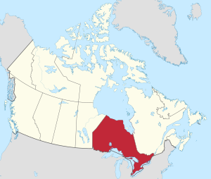
Ontario (/ɒnˈtɛərioʊ/ on-TAIR-ee-oh; French: [ɔ̃taʁjo]) is the southernmost province of Canada.[9][note 1] Located in Central Canada,[10] Ontario is the country's most populous province. As of the 2021 Canadian census, it is home to 38.5 per cent of the country's population, and is the second-largest province by total area (after Quebec).[3][11] Ontario is Canada's fourth-largest jurisdiction in total area of all the Canadian provinces and territories.[11] It is home to the nation's capital, Ottawa, and its most populous city, Toronto,[12] which is Ontario's provincial capital.
Ontario is bordered by the province of Manitoba to the west, Hudson Bay and James Bay to the north, and Quebec to the east and northeast. To the south, it is bordered by the U.S. states of (from west to east) Minnesota, Michigan, Ohio, Pennsylvania, and New York. Almost all of Ontario's 2,700 km (1,700 mi) border with the United States follows rivers and lakes: from the westerly Lake of the Woods, eastward along the major rivers and lakes of the Great Lakes/Saint Lawrence River drainage system. There is only about 1 km (5⁄8 mi) of actual land border, made up of portages including Height of Land Portage on the Minnesota border.[13]
The great majority of Ontario's population and arable land is in Southern Ontario, and while agriculture remains a significant industry, the region's economy depends highly on manufacturing. In contrast, Northern Ontario is sparsely populated with cold winters and heavy forestation,[14] with mining and forestry making up the region's major industries.
- ^ "Ontario". Geographical Names Data Base. Natural Resources Canada.
- ^ "Population and dwelling counts: Canada, provinces and territories". Statistics Canada. February 9, 2022. Archived from the original on February 9, 2022. Retrieved February 9, 2022.
- ^ a b "Population and dwelling counts: Canada, provinces and territories". Statistics Canada. September 2, 2022. Archived from the original on April 11, 2023. Retrieved October 7, 2023.
- ^ "Population estimates, quarterly". Statistics Canada. September 27, 2023. Archived from the original on September 28, 2023. Retrieved September 28, 2023.
- ^ "Definition of Ontarian". Collins Online Dictionary. HarperCollins Publishers. Archived from the original on October 4, 2013. Retrieved October 3, 2013.
- ^ "About Ontario". Ontario.ca. Queen's Printer for Ontario. March 7, 2019. Archived from the original on January 8, 2020. Retrieved January 8, 2020.
- ^ "Ontario Economic Accounts". Government of Ontario. July 13, 2023. Archived from the original on April 14, 2023. Retrieved September 15, 2023.
- ^ "Sub-national HDI – Subnational HDI – Global Data Lab". Archived from the original on September 25, 2021. Retrieved September 8, 2021.
- ^ "Get to know Canada - Provinces and territories". Government of Canada, Immigration, Refugees and Citizenship Canada. July 12, 2017. Archived from the original on December 31, 2017. Retrieved October 7, 2023.
- ^ a b "Discover Canada - Canada's Regions". Government of Canada, Immigration, Refugees and Citizenship Canada. July 1, 2012. Archived from the original on August 6, 2023. Retrieved October 7, 2023.
- ^ a b "Table 15.7 Land and freshwater area, by province and territory". www150.statcan.gc.ca. Retrieved November 1, 2023.
- ^ "Population of census metropolitan areas (2001 Census boundaries)". Statistics Canada. Archived from the original on July 24, 2005. Retrieved January 5, 2007.
- ^ Canada/United States International Boundary Commission (2006). "St. Lawrence River and Great Lakes" (PDF). Presentation at 2006 IBRU Conference, p. 21. Durham University. Archived (PDF) from the original on November 2, 2012. Retrieved May 6, 2014.
- ^ "Ontario Population Projections, 2018–2046". Government of Ontario Ministry of Finance. Archived from the original on March 28, 2020. Retrieved April 12, 2020.
Cite error: There are <ref group=note> tags on this page, but the references will not show without a {{reflist|group=note}} template (see the help page).


