Orangevale | |
|---|---|
 | |
| Coordinates: 38°40′55″N 121°12′50″W / 38.68194°N 121.21389°W | |
| Country | |
| State | |
| County | Sacramento |
| Area | |
| • Total | 11.646 sq mi (30.16 km2) |
| • Land | 11.515 sq mi (29.82 km2) |
| • Water | 0.131 sq mi (0.34 km2) 1.13% |
| Elevation | 240 ft (73 m) |
| Population (2020) | |
| • Total | 35,569[1] |
| Time zone | UTC-8 (PST) |
| • Summer (DST) | UTC-7 (PDT) |
| ZIP code | 95662 |
| Area code(s) | 916, 279 |
| FIPS code | 06-54092 |
| GNIS feature ID | 1656200 |
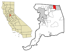
Orangevale is a census-designated place (CDP) in Sacramento County, California, United States. It is part of the Sacramento–Arden-Arcade–Roseville Metropolitan Statistical Area. The population was 33,960 at the 2010 census, up from 26,705 at the 2000 census. It is located approximately 25 miles (40 km) northeast of Sacramento. The community is known for its rolling hills that offer the best views of the Sierra Nevada mountain range, its foothills, and a rural environment in the middle of a growing metropolitan area. Some residential properties in the area are zoned to accommodate horses and orchards. It has a ZIP Code of 95662.
- ^ "Explore Census Data". data.census.gov. Retrieved May 1, 2023.
- ^ U.S. Census Archived 2012-01-25 at the Wayback Machine
- ^ "Orangevale, California". City-Data.com. Retrieved July 25, 2007.