Orchard, Texas | |
|---|---|
 Orchard's distinctive water tower | |
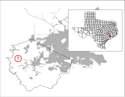
 Location of Orchard, Texas | |
| Coordinates: 29°36′7″N 95°58′8″W / 29.60194°N 95.96889°W | |
| Country | United States |
| State | Texas |
| County | Fort Bend |
| Area | |
| • Total | 0.36 sq mi (0.94 km2) |
| • Land | 0.36 sq mi (0.94 km2) |
| • Water | 0.00 sq mi (0.00 km2) |
| Elevation | 125 ft (38 m) |
| Population (2020) | |
| • Total | 313 |
| • Density | 870/sq mi (330/km2) |
| Time zone | UTC-6 (Central (CST)) |
| • Summer (DST) | UTC-5 (CDT) |
| ZIP code | 77464 |
| Area code | 979 |
| FIPS code | 48-54192[2] |
| GNIS feature ID | 1343307[3] |
| Website | orchardtexas |
Orchard is a city in western Fort Bend County, Texas, United States, within the Houston–Sugar Land–Baytown metropolitan area. The community is located along State Highway 36 (SH 36) and the BNSF Railway between Rosenberg in Fort Bend County and Wallis in Austin County. The population was 313 at the 2020 census, down from 352 at the 2010 census.[4]
- ^ "2019 U.S. Gazetteer Files". United States Census Bureau. Retrieved August 7, 2020.
- ^ "U.S. Census website". United States Census Bureau. Retrieved January 31, 2008.
- ^ "US Board on Geographic Names". United States Geological Survey. October 25, 2007. Retrieved January 31, 2008.
- ^ "Geographic Identifiers: 2010 Demographic Profile Data (G001): Orchard city, Texas". U.S. Census Bureau, American Factfinder. Retrieved August 30, 2016.[dead link]