| Scottish Gaelic name | Orasaigh |
|---|---|
| Pronunciation | [ˈɔɾəs̪aj] |
| Old Norse name | [possibly] Örfirisey[1] |
| Meaning of name | "tidal island"[2] or "Oran's isle"[3] |
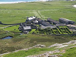
 Oronsay Priory and Farm | |
| Location | |
| OS grid reference | NR351892 |
| Coordinates | 56°01′N 6°14′W / 56.02°N 6.24°W |
| Physical geography | |
| Island group | Inner Hebrides |
| Area | 543 ha (1,340 acres) |
| Area rank | 71 [4] |
| Highest elevation | Beinn Orasaigh, 93 m (305 ft) |
| Administration | |
| Council area | Argyll and Bute |
| Country | Scotland |
| Sovereign state | United Kingdom |
| Demographics | |
| Population | 8[5] |
| Population rank | 70= [4] |
| Population density | 1.5/km2 (3.9/sq mi)[3][5] |
| Largest settlement | Oronsay Farm |
| References | [3][6] |
Oronsay (Scottish Gaelic: Orasaigh), also sometimes spelt and pronounced Oransay by the local community, is a small tidal island south of Colonsay in the Scottish Inner Hebrides with an area of 543 hectares (1,340 acres).[3][note 1]
The island rises to a height of 93 metres (305 feet) at Beinn Orasaigh and is linked to Colonsay by a tidal causeway called An Tràigh (The Strand) consisting of sands and mud flats. In the 2001 census Oronsay was recorded as having a population of five people, who lived at the farm adjacent to Oronsay Priory. In 2011 the population had risen to eight.[5] The island has no facilities for visitors and is now privately owned, with the RSPB farming the island for the American owner.[8] It is dependent upon tidal access to and from Colonsay. There is a small grass air strip south of the priory that "fights a losing battle with the rabbits".[3]
- ^ Cite error: The named reference
Watsonwas invoked but never defined (see the help page). - ^ Mac an Tàilleir (2003) p. 93
- ^ a b c d e Haswell-Smith (2004) pp. 52–56.
- ^ a b Area and population ranks: there are c. 300 islands over 20 ha in extent and 93 permanently inhabited islands were listed in the 2011 census.
- ^ a b c National Records of Scotland (15 August 2013). "Appendix 2: Population and households on Scotland's Inhabited Islands" (PDF). Statistical Bulletin: 2011 Census: First Results on Population and Household Estimates for Scotland Release 1C (Part Two) (PDF) (Report). SG/2013/126. Retrieved 14 August 2020.
- ^ Ordnance Survey. OS Maps Online (Map). 1:25,000. Leisure.
- ^ "Gazetteer for Scotland Oronsay". The Gazetteer for Scotland. Retrieved 24 March 2014.
- ^ "RSPB: Oronsay". Retrieved 23 June 2021.
Cite error: There are <ref group=note> tags on this page, but the references will not show without a {{reflist|group=note}} template (see the help page).
