 | |
 Street routing | |
| Developer(s) | Victor Shcherb, Alexey Pelykh, Hardy Mueller and others |
|---|---|
| Initial release | June 1, 2010 |
| Stable release | |
| Repository | |
| Written in | Java, C++ |
| Operating system | Android, iOS |
| Size | 39.0 MB |
| License | Licensing |
| Website | osmand |
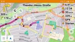
OsmAnd (/ˈoʊsəmænd/;[3] OpenStreetMap Automated Navigation Directions) is a map and navigation app for Android and iOS.[4] It uses the OpenStreetMap (OSM) map database for its primary displays, but is an independent app not endorsed by the OpenStreetMap Foundation. It is available in both free and paid versions; the latter unlocks the download limit for offline maps and provides access to Wikipedia points of interest (POIs) and their descriptions from within the app. Map data can be stored on the device for offline use. Using the device's GPS capabilities, OsmAnd offers routing, with visual and voice guidance, for car, bike, and pedestrian. All of the main functionalities work both online and offline.[5]
- ^ "OsmAnd 4.8 (Android)". 26 July 2024. Retrieved 27 July 2024.
- ^ Eugene (22 August 2024). "OsmAnd 4.8 (iOS) | OsmAnd". Retrieved 26 September 2024.
- ^ "OsmAnd Maps & Navigation - free offline maps for Android and iOS". YouTube. March 30, 2017. Retrieved October 12, 2020.
- ^ "OsmAnd for iPhone is released". osmand.net. 3 June 2023.
- ^ "OsmAnd Maps: a genius and helpful MapsApp". theappzine.com. May 31, 2015.