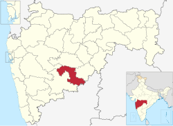
Osmanabad District | |
|---|---|
| Dharashiv District | |
 Location in Maharashtra | |
| Coordinates (Osmanabad): 17°21′N 75°10′E / 17.35°N 75.16°E-18°24′N 76°24′E / 18.40°N 76.40°E | |
| Country | |
| State | Maharashtra |
| Division | Aurangabad |
| Headquarters | Osmanabad |
| Tehsils | |
| Government | |
| • Body | Osmanabad Zilla Parishad |
| • Guardian Minister | Tanaji Sawant (Cabinet Minister MH) |
| • President Z. P. Osmanabad | N/A |
| • District Collector | Sachin Ombase (IAS) |
| • CEO Z. P. Osmanabad | Rahul Gupta (IAS) |
| • MPs | Omraje Nimbalkar (Osmanabad) |
| Area | |
• Total | 7,569 km2 (2,922 sq mi) |
| Population (2011) | |
• Total | 1,657,576 |
| • Density | 220/km2 (570/sq mi) |
| Demographics | |
| • Literacy | 76.33% |
| • Sex ratio | 920 |
| Time zone | UTC+05:30 (IST) |
| Major highways | National Highway 52, National Highway 65, National Highway 361 |
| Average annual precipitation | 760.40 mm |
| Website | dharashiv |
Osmanabad District (pronunciation: [usmaːnabaːd̪]) (Transliteration: Usmanabad Jil'hā), officially known as Dharashiv District,[1] is an administrative district in the Marathwada region in the Indian state of Maharashtra. The district headquarter is located at Osmanabad. The District of Osmanabad derives its name from the last ruler of Hyderabad, the 7th Nizam, Mir Osman Ali Khan, of which the region was a part till 1947. This region was earlier part of The Hyderabad State until Independence.This primarily rural district occupies an area of 7,569 km2 (2,922 sq mi) of which 241.4 km2 (93.2 sq mi) is urban and has a population of 1,657,576 of which 16.96% were urban (as of 2011).[2]
- ^ Malik, Faisal (16 September 2023). "Aurangabad formally renamed Chhatrapati Sambhajinagar, Osmanabad as Dharashiv". Hindustan Times. Retrieved 24 November 2023.
- ^ Cite error: The named reference
districtcensuswas invoked but never defined (see the help page).


