Ottawa Central Station | |||||
|---|---|---|---|---|---|
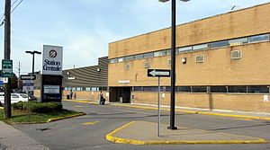
 Bus station while it was operated by Station Centrale | |||||
| General information | |||||
| Location | 265 Catherine Street Ottawa, Ontario K1R 7S5 | ||||
| Coordinates | 45°24′31″N 75°41′41″W / 45.40861°N 75.69472°W | ||||
| Owned by | Brigil Real Estate Society | ||||
| Bus stands | 14 (4 for arrivals) | ||||
| Connections | |||||
| Construction | |||||
| Structure type | At-grade | ||||
| Parking | Paid parking - short and long term | ||||
| Bicycle facilities | Yes | ||||
| Accessible | Yes | ||||
| Other information | |||||
| Website | Last snapshot of official website in August 2020 | ||||
| History | |||||
| Opened | 1972 | ||||
| Closed | June 1, 2021 | ||||
 | |||||
Ottawa Central Station was the main inter-city bus station in Ottawa, Ontario, Canada. It was located 1.5 km south of downtown Ottawa in the Centretown neighbourhood and served buses from Greyhound Canada, Ontario Northland and Autobus Gatineau.[1] It closed on June 1, 2021, and the land it sat on is now owned by Brigil, a real estate developer, who plans to build a multi-use space for housing, dining, retail, and other businesses.[2]
Ottawa Central Station was located at 265 Catherine Street, between Lyon Street and Kent Street. Catherine Street lies directly north of Ontario Highway 417 (known locally as the Queensway), which is the main expressway through Ottawa. The former station was accessible from highway 417 exits 120 (eastbound) and 119 (westbound).
The station's main entrance faced south towards Catherine Street and the 417. On the north side of the station building, buses called at 14 outdoor bus stands with adjoining indoor gates. The front of the buses were partially covered by a roof overhang.
The property it sat on is located one block west of Bank Street, a major north-south commercial street in Ottawa. Continuing north on Bank Street leads to downtown and the main government and business district, while south of highway 417, the street passes through the more residential neighbourhood of the Glebe on its way to Landsdowne Park and the Rideau Canal.
Nearby landmarks include the Canadian Museum of Nature on Metcalfe Street and beyond that, the southern end of Elgin Street, a north-south commercial street with many small shops, restaurants and bars.
Ottawa Central Station was located roughly 5 kilometres (3.1 mi) west of the Ottawa Train Station[3] and 11 kilometres (6.8 mi) north of Ottawa Macdonald–Cartier International Airport.[4]
- ^ Autobus Gatineau
- ^ "'Everything is on the table' for former Greyhound station, says developer | CBC News". Archived from the original on 2021-03-03. Retrieved 2021-06-25.
- ^ "Ottawa Central Station to Ottawa Station via Trans-Canada Hwy/ON-417 E" (Map). Google Maps. Retrieved 8 January 2021.
- ^ "Ottawa Central Station to Ottawa International Airport via route 79 S" (Map). Google Maps. Retrieved 8 January 2021.


