| Oulton Broad | |
|---|---|
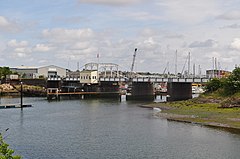
 Oulton Broad Swingbridge | |
Location within Suffolk | |
| Area | 5 km2 (1.9 sq mi) [1] |
| Population | 10,338 (2011 est.)[1] |
| • Density | 2,068/km2 (5,360/sq mi) |
| OS grid reference | TM521928 |
| District | |
| Shire county | |
| Region | |
| Country | England |
| Sovereign state | United Kingdom |
| Post town | Lowestoft |
| Postcode district | NR32, NR33 |
| Dialling code | 01502 |
| UK Parliament | |
Oulton Broad refers to both the lake and the suburb of Lowestoft in the English county of Suffolk.
The suburb is located 2 miles (3.2 km) west of the centre of Lowestoft. It became a civil parish in 2017.[1][2] It had an estimated population of 10,338 at the 2011 United Kingdom census.[a][1]
- ^ a b c d e Town profile: Oulton Broad, East Suffolk District Council, 2019. Retrieved 6 March 2021.
- ^ Waveney District Council (Reorganisation of Community Governance) Order 2017, Local Government Boundary Commission for England, 2017. Retrieved 16 May 2018.
Cite error: There are <ref group=lower-alpha> tags or {{efn}} templates on this page, but the references will not show without a {{reflist|group=lower-alpha}} template or {{notelist}} template (see the help page).
