| Ourimbah Central Coast, New South Wales | |||||||||||||||
|---|---|---|---|---|---|---|---|---|---|---|---|---|---|---|---|
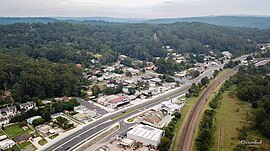
 Aerial shot of Ourimbah in April 2019 | |||||||||||||||
 | |||||||||||||||
| Coordinates | 33°21′54″S 151°22′5″E / 33.36500°S 151.36806°E | ||||||||||||||
| Population | 3,951 (2016 census)[1] | ||||||||||||||
| Postcode(s) | 2258 | ||||||||||||||
| Elevation | 37 m (121 ft) | ||||||||||||||
| Location |
| ||||||||||||||
| LGA(s) | Central Coast Council | ||||||||||||||
| Parish | Ourimbah | ||||||||||||||
| State electorate(s) | |||||||||||||||
| Federal division(s) | Dobell | ||||||||||||||
| |||||||||||||||
Ourimbah (/ɔːrɪmbɑː/) is a small township in the Central Coast region of New South Wales, Australia, located about 78 kilometres (48 mi) north of the state capital Sydney. Ourimbah is located approximately halfway between Sydney and Newcastle. The township today consists of small scattered local shops and businesses along the Pacific Highway, as well as the Central Coast campus of the University of Newcastle. Ourimbah had a population of 3,951 at the 2016 census.[1]
- ^ a b Australian Bureau of Statistics (27 June 2017). "Ourimbah (State Suburb)". 2016 Census QuickStats. Retrieved 1 January 2020.
